You are here: Home > Network List > IU - Global Seismograph Network (GSN - IRIS/USGS) Stations List
> Station PMG Port Moresby, New Guinea > Earthquake Result Viewer
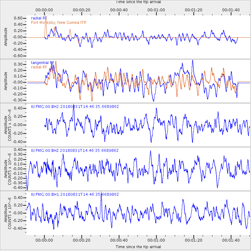
PMG Port Moresby, New Guinea - Earthquake Result Viewer
*The percent match for this event was below the threshold and hence no stack was calculated.
| Earthquake location: |
Mindoro, Philippines |
| Earthquake latitude/longitude: |
13.6/120.9 |
| Earthquake time(UTC): |
2018/08/31 (243) 14:40:29 GMT |
| Earthquake Depth: |
140 km |
| Earthquake Magnitude: |
5.5 Mww |
| Earthquake Catalog/Contributor: |
NEIC PDE/us |
|
| Network: |
IU Global Seismograph Network (GSN - IRIS/USGS) |
| Station: |
PMG Port Moresby, New Guinea |
| Lat/Lon: |
9.40 S/147.16 E |
| Elevation: |
90 m |
|
| Distance: |
34.6 deg |
| Az: |
129.821 deg |
| Baz: |
310.803 deg |
| Ray Param: |
$rayparam |
*The percent match for this event was below the threshold and hence was not used in the summary stack. |
|
| Radial Match: |
50.679626 % |
| Radial Bump: |
400 |
| Transverse Match: |
52.55412 % |
| Transverse Bump: |
400 |
| SOD ConfigId: |
3045211 |
| Insert Time: |
2018-10-09 19:55:31.259 +0000 |
| GWidth: |
2.5 |
| Max Bumps: |
400 |
| Tol: |
0.001 |
|
Signal To Noise
| Channel | StoN | STA | LTA |
| IU:PMG:00:BHZ:20180831T14:46:35.668986Z | 0.7738366 | 9.7166264E-8 | 1.2556431E-7 |
| IU:PMG:00:BH1:20180831T14:46:35.668986Z | 1.261252 | 1.7311069E-7 | 1.3725305E-7 |
| IU:PMG:00:BH2:20180831T14:46:35.668986Z | 1.2772831 | 1.7766067E-7 | 1.3909262E-7 |
| Arrivals |
| Ps | |
| PpPs | |
| PsPs/PpSs | |


