You are here: Home > Network List > AK - Alaska Regional Network Stations List
> Station K20K Telida, AK, USA > Earthquake Result Viewer
K20K Telida, AK, USA - Earthquake Result Viewer
| Earthquake location: |
Hokkaido, Japan Region |
| Earthquake latitude/longitude: |
42.8/145.1 |
| Earthquake time(UTC): |
2023/02/25 (056) 13:27:42 GMT |
| Earthquake Depth: |
43 km |
| Earthquake Magnitude: |
6.1 Mww |
| Earthquake Catalog/Contributor: |
NEIC PDE/us |
|
| Network: |
AK Alaska Regional Network |
| Station: |
K20K Telida, AK, USA |
| Lat/Lon: |
63.36 N/154.07 W |
| Elevation: |
548 m |
|
| Distance: |
40.0 deg |
| Az: |
37.726 deg |
| Baz: |
268.585 deg |
| Ray Param: |
0.074535936 |
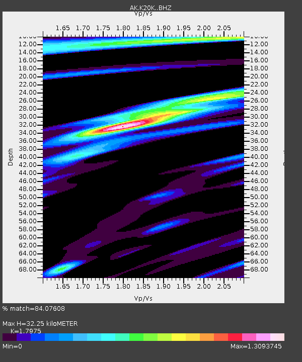
| Estimated Moho Depth: |
32.25 km |
| Estimated Crust Vp/Vs: |
1.80 |
| Assumed Crust Vp: |
6.438 km/s |
| Estimated Crust Vs: |
3.582 km/s |
| Estimated Crust Poisson's Ratio: |
0.28 |
|
| Radial Match: |
84.07608 % |
| Radial Bump: |
400 |
| Transverse Match: |
75.57972 % |
| Transverse Bump: |
400 |
| SOD ConfigId: |
29823551 |
| Insert Time: |
2023-03-11 13:31:32.727 +0000 |
| GWidth: |
2.5 |
| Max Bumps: |
400 |
| Tol: |
0.001 |
|

Signal To Noise
| Channel | StoN | STA | LTA |
| AK:K20K: :BHZ:20230225T13:34:42.620011Z | 8.315956 | 2.567453E-6 | 3.0873818E-7 |
| AK:K20K: :BHN:20230225T13:34:42.620011Z | 1.9769434 | 4.6049894E-7 | 2.3293482E-7 |
| AK:K20K: :BHE:20230225T13:34:42.620011Z | 6.1486135 | 1.5103237E-6 | 2.4563647E-7 |
| Arrivals |
| Ps | 4.3 SECOND |
| PpPs | 13 SECOND |
| PsPs/PpSs | 17 SECOND |


