You are here: Home > Network List > AV - Alaska Volcano Observatory Stations List
> Station MAPS Pakushin Southeast, Makushin Volcano, Alaska > Earthquake Result Viewer
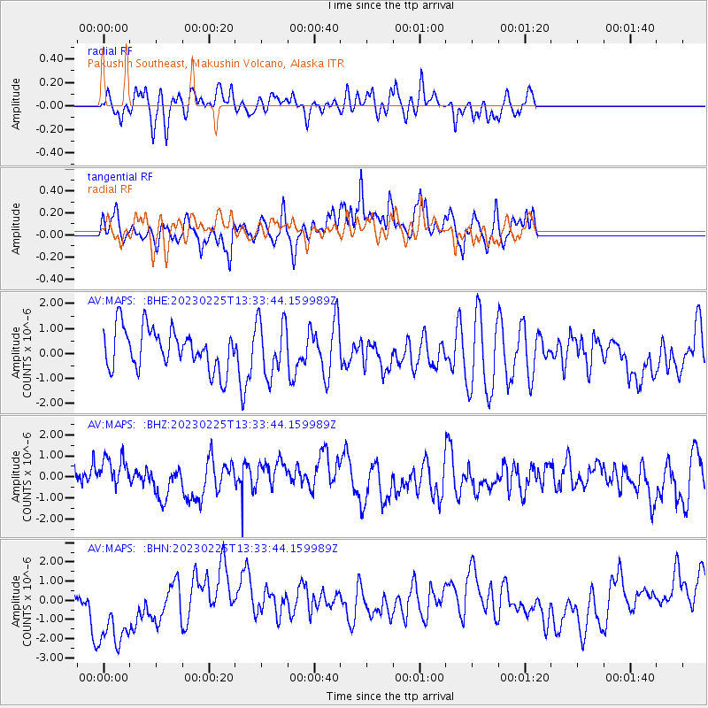
MAPS Pakushin Southeast, Makushin Volcano, Alaska - Earthquake Result Viewer
*The percent match for this event was below the threshold and hence no stack was calculated.
| Earthquake location: |
Hokkaido, Japan Region |
| Earthquake latitude/longitude: |
42.8/145.1 |
| Earthquake time(UTC): |
2023/02/25 (056) 13:27:42 GMT |
| Earthquake Depth: |
43 km |
| Earthquake Magnitude: |
6.1 Mww |
| Earthquake Catalog/Contributor: |
NEIC PDE/us |
|
| Network: |
AV Alaska Volcano Observatory |
| Station: |
MAPS Pakushin Southeast, Makushin Volcano, Alaska |
| Lat/Lon: |
53.81 N/166.94 W |
| Elevation: |
333 m |
|
| Distance: |
33.1 deg |
| Az: |
53.625 deg |
| Baz: |
270.389 deg |
| Ray Param: |
$rayparam |
*The percent match for this event was below the threshold and hence was not used in the summary stack. |
|
| Radial Match: |
44.32799 % |
| Radial Bump: |
400 |
| Transverse Match: |
64.47457 % |
| Transverse Bump: |
400 |
| SOD ConfigId: |
29823551 |
| Insert Time: |
2023-03-11 13:35:00.867 +0000 |
| GWidth: |
2.5 |
| Max Bumps: |
400 |
| Tol: |
0.001 |
|
Signal To Noise
| Channel | StoN | STA | LTA |
| AV:MAPS: :BHZ:20230225T13:33:44.159989Z | 1.2190549 | 8.3551663E-7 | 6.853806E-7 |
| AV:MAPS: :BHN:20230225T13:33:44.159989Z | 2.5830019 | 2.3934845E-6 | 9.26629E-7 |
| AV:MAPS: :BHE:20230225T13:33:44.159989Z | 1.3610175 | 1.0985923E-6 | 8.071846E-7 |
| Arrivals |
| Ps | |
| PpPs | |
| PsPs/PpSs | |


