You are here: Home > Network List > CC - Cascade Chain Volcano Monitoring Stations List
> Station STD Studebaker Ridge, Mount St. Helens > Earthquake Result Viewer
STD Studebaker Ridge, Mount St. Helens - Earthquake Result Viewer
| Earthquake location: |
Hokkaido, Japan Region |
| Earthquake latitude/longitude: |
42.8/145.1 |
| Earthquake time(UTC): |
2023/02/25 (056) 13:27:42 GMT |
| Earthquake Depth: |
43 km |
| Earthquake Magnitude: |
6.1 Mww |
| Earthquake Catalog/Contributor: |
NEIC PDE/us |
|
| Network: |
CC Cascade Chain Volcano Monitoring |
| Station: |
STD Studebaker Ridge, Mount St. Helens |
| Lat/Lon: |
46.24 N/122.22 W |
| Elevation: |
1189 m |
|
| Distance: |
62.4 deg |
| Az: |
51.481 deg |
| Baz: |
303.87 deg |
| Ray Param: |
0.060166642 |
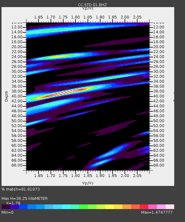
| Estimated Moho Depth: |
38.25 km |
| Estimated Crust Vp/Vs: |
1.76 |
| Assumed Crust Vp: |
6.566 km/s |
| Estimated Crust Vs: |
3.731 km/s |
| Estimated Crust Poisson's Ratio: |
0.26 |
|
| Radial Match: |
81.81873 % |
| Radial Bump: |
400 |
| Transverse Match: |
66.45739 % |
| Transverse Bump: |
400 |
| SOD ConfigId: |
29823551 |
| Insert Time: |
2023-03-11 13:38:48.257 +0000 |
| GWidth: |
2.5 |
| Max Bumps: |
400 |
| Tol: |
0.001 |
|

Signal To Noise
| Channel | StoN | STA | LTA |
| CC:STD:01:BHZ:20230225T13:37:29.919999Z | 5.120409 | 8.463366E-7 | 1.652869E-7 |
| CC:STD:01:BHN:20230225T13:37:29.919999Z | 3.423253 | 5.0852225E-7 | 1.4854942E-7 |
| CC:STD:01:BHE:20230225T13:37:29.919999Z | 3.3421612 | 5.3182526E-7 | 1.5912616E-7 |
| Arrivals |
| Ps | 4.6 SECOND |
| PpPs | 15 SECOND |
| PsPs/PpSs | 20 SECOND |


