You are here: Home > Network List > IU - Global Seismograph Network (GSN - IRIS/USGS) Stations List
> Station POHA Pohakuloa, Hawaii, USA > Earthquake Result Viewer
POHA Pohakuloa, Hawaii, USA - Earthquake Result Viewer
*The percent match for this event was below the threshold and hence no stack was calculated.
| Earthquake location: |
Fiji Islands |
| Earthquake latitude/longitude: |
-18.4/179.5 |
| Earthquake time(UTC): |
2018/09/06 (249) 15:49:17 GMT |
| Earthquake Depth: |
669 km |
| Earthquake Magnitude: |
8.1 Mi |
| Earthquake Catalog/Contributor: |
NEIC PDE/at |
|
| Network: |
IU Global Seismograph Network (GSN - IRIS/USGS) |
| Station: |
POHA Pohakuloa, Hawaii, USA |
| Lat/Lon: |
19.76 N/155.53 W |
| Elevation: |
1990 m |
|
| Distance: |
45.1 deg |
| Az: |
34.111 deg |
| Baz: |
214.427 deg |
| Ray Param: |
$rayparam |
*The percent match for this event was below the threshold and hence was not used in the summary stack. |
|
| Radial Match: |
88.22989 % |
| Radial Bump: |
400 |
| Transverse Match: |
76.7374 % |
| Transverse Bump: |
400 |
| SOD ConfigId: |
3045211 |
| Insert Time: |
2018-10-09 20:44:14.112 +0000 |
| GWidth: |
2.5 |
| Max Bumps: |
400 |
| Tol: |
0.001 |
|
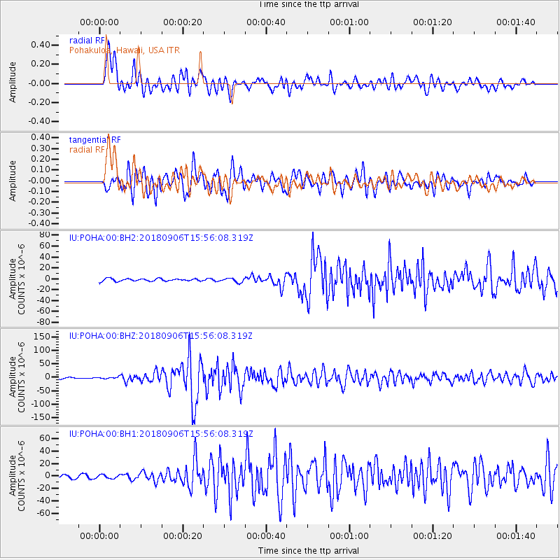
Signal To Noise
| Channel | StoN | STA | LTA |
| IU:POHA:00:BHZ:20180906T15:56:08.319Z | 1.507532 | 2.950378E-6 | 1.9570916E-6 |
| IU:POHA:00:BH1:20180906T15:56:08.319Z | 0.97245675 | 2.8628428E-6 | 2.9439282E-6 |
| IU:POHA:00:BH2:20180906T15:56:08.319Z | 1.1014932 | 2.5188247E-6 | 2.2867366E-6 |
| Arrivals |
| Ps | |
| PpPs | |
| PsPs/PpSs | |


