You are here: Home > Network List > IU - Global Seismograph Network (GSN - IRIS/USGS) Stations List
> Station PMG Port Moresby, New Guinea > Earthquake Result Viewer
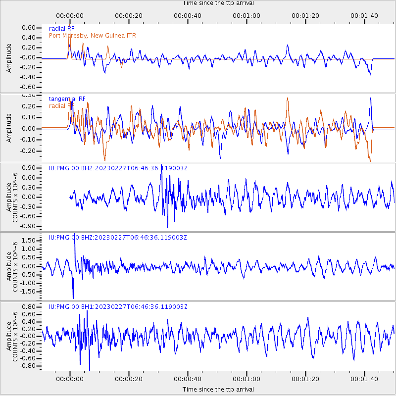
PMG Port Moresby, New Guinea - Earthquake Result Viewer
*The percent match for this event was below the threshold and hence no stack was calculated.
| Earthquake location: |
Fiji Islands Region |
| Earthquake latitude/longitude: |
-20.5/-178.4 |
| Earthquake time(UTC): |
2023/02/27 (058) 06:40:59 GMT |
| Earthquake Depth: |
548 km |
| Earthquake Magnitude: |
5.6 Mww |
| Earthquake Catalog/Contributor: |
NEIC PDE/us |
|
| Network: |
IU Global Seismograph Network (GSN - IRIS/USGS) |
| Station: |
PMG Port Moresby, New Guinea |
| Lat/Lon: |
9.40 S/147.16 E |
| Elevation: |
90 m |
|
| Distance: |
35.0 deg |
| Az: |
283.243 deg |
| Baz: |
112.393 deg |
| Ray Param: |
$rayparam |
*The percent match for this event was below the threshold and hence was not used in the summary stack. |
|
| Radial Match: |
52.500782 % |
| Radial Bump: |
400 |
| Transverse Match: |
54.20524 % |
| Transverse Bump: |
400 |
| SOD ConfigId: |
29823551 |
| Insert Time: |
2023-03-13 06:54:45.174 +0000 |
| GWidth: |
2.5 |
| Max Bumps: |
400 |
| Tol: |
0.001 |
|
Signal To Noise
| Channel | StoN | STA | LTA |
| IU:PMG:00:BHZ:20230227T06:46:36.119003Z | 4.070646 | 6.264156E-7 | 1.5388606E-7 |
| IU:PMG:00:BH1:20230227T06:46:36.119003Z | 1.5581446 | 2.3585463E-7 | 1.513689E-7 |
| IU:PMG:00:BH2:20230227T06:46:36.119003Z | 2.5231028 | 4.1478435E-7 | 1.6439455E-7 |
| Arrivals |
| Ps | |
| PpPs | |
| PsPs/PpSs | |


