You are here: Home > Network List > TX - Texas Seismological Network Stations List
> Station WTFS Witchita Falls > Earthquake Result Viewer
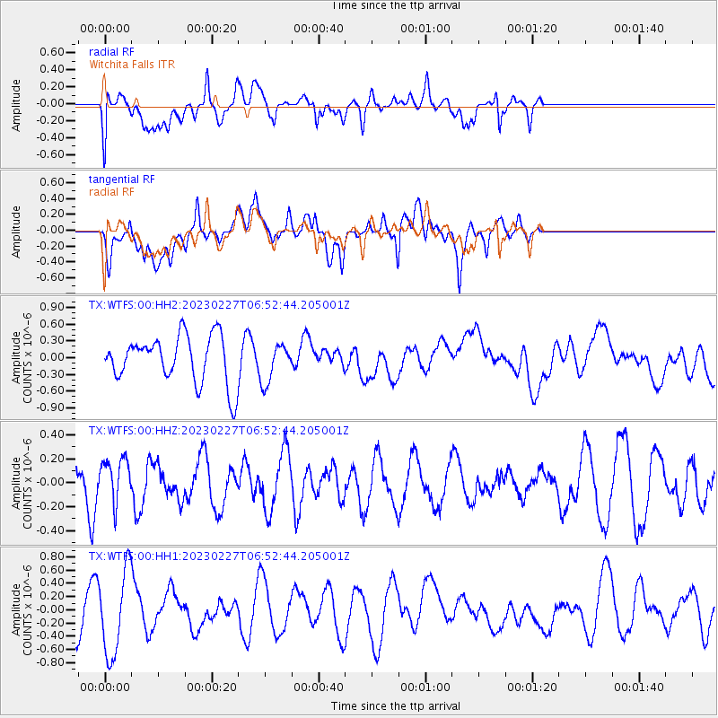
WTFS Witchita Falls - Earthquake Result Viewer
*The percent match for this event was below the threshold and hence no stack was calculated.
| Earthquake location: |
Fiji Islands Region |
| Earthquake latitude/longitude: |
-20.5/-178.4 |
| Earthquake time(UTC): |
2023/02/27 (058) 06:40:59 GMT |
| Earthquake Depth: |
548 km |
| Earthquake Magnitude: |
5.6 Mww |
| Earthquake Catalog/Contributor: |
NEIC PDE/us |
|
| Network: |
TX Texas Seismological Network |
| Station: |
WTFS Witchita Falls |
| Lat/Lon: |
33.77 N/98.46 W |
| Elevation: |
277 m |
|
| Distance: |
93.2 deg |
| Az: |
55.226 deg |
| Baz: |
247.543 deg |
| Ray Param: |
$rayparam |
*The percent match for this event was below the threshold and hence was not used in the summary stack. |
|
| Radial Match: |
52.516266 % |
| Radial Bump: |
400 |
| Transverse Match: |
46.629982 % |
| Transverse Bump: |
400 |
| SOD ConfigId: |
29823551 |
| Insert Time: |
2023-03-13 07:01:21.535 +0000 |
| GWidth: |
2.5 |
| Max Bumps: |
400 |
| Tol: |
0.001 |
|
Signal To Noise
| Channel | StoN | STA | LTA |
| TX:WTFS:00:HHZ:20230227T06:52:44.205001Z | 0.9274193 | 1.8265096E-7 | 1.969454E-7 |
| TX:WTFS:00:HH1:20230227T06:52:44.205001Z | 2.522413 | 6.412527E-7 | 2.5422193E-7 |
| TX:WTFS:00:HH2:20230227T06:52:44.205001Z | 0.8234653 | 3.4598358E-7 | 4.2015563E-7 |
| Arrivals |
| Ps | |
| PpPs | |
| PsPs/PpSs | |


