You are here: Home > Network List > IU - Global Seismograph Network (GSN - IRIS/USGS) Stations List
> Station RSSD Black Hills, South Dakota, USA > Earthquake Result Viewer
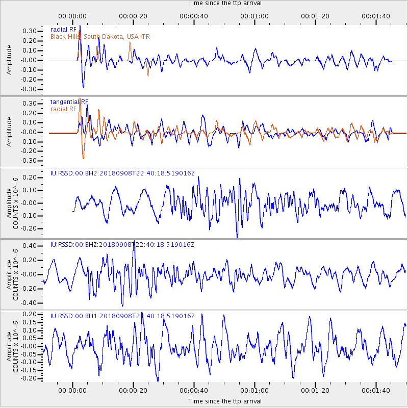
RSSD Black Hills, South Dakota, USA - Earthquake Result Viewer
*The percent match for this event was below the threshold and hence no stack was calculated.
| Earthquake location: |
South Of Tonga Islands |
| Earthquake latitude/longitude: |
-24.5/-175.6 |
| Earthquake time(UTC): |
2018/09/08 (251) 22:27:27 GMT |
| Earthquake Depth: |
10 km |
| Earthquake Magnitude: |
5.5 Mww |
| Earthquake Catalog/Contributor: |
NEIC PDE/us |
|
| Network: |
IU Global Seismograph Network (GSN - IRIS/USGS) |
| Station: |
RSSD Black Hills, South Dakota, USA |
| Lat/Lon: |
44.12 N/104.04 W |
| Elevation: |
2090 m |
|
| Distance: |
94.5 deg |
| Az: |
43.249 deg |
| Baz: |
240.1 deg |
| Ray Param: |
$rayparam |
*The percent match for this event was below the threshold and hence was not used in the summary stack. |
|
| Radial Match: |
63.703022 % |
| Radial Bump: |
400 |
| Transverse Match: |
78.98633 % |
| Transverse Bump: |
392 |
| SOD ConfigId: |
3045211 |
| Insert Time: |
2018-10-09 21:06:55.086 +0000 |
| GWidth: |
2.5 |
| Max Bumps: |
400 |
| Tol: |
0.001 |
|
Signal To Noise
| Channel | StoN | STA | LTA |
| IU:RSSD:00:BHZ:20180908T22:40:18.519016Z | 1.2454494 | 1.3946436E-7 | 1.1197915E-7 |
| IU:RSSD:00:BH1:20180908T22:40:18.519016Z | 1.0936191 | 5.865078E-8 | 5.3629986E-8 |
| IU:RSSD:00:BH2:20180908T22:40:18.519016Z | 1.6427606 | 9.834453E-8 | 5.98654E-8 |
| Arrivals |
| Ps | |
| PpPs | |
| PsPs/PpSs | |


