You are here: Home > Network List > AU - Australian Seismological Centre Stations List
> Station KMBL Kambalda, WA > Earthquake Result Viewer
KMBL Kambalda, WA - Earthquake Result Viewer
| Earthquake location: |
Bismarck Sea |
| Earthquake latitude/longitude: |
-4.8/149.6 |
| Earthquake time(UTC): |
2023/03/01 (060) 05:36:14 GMT |
| Earthquake Depth: |
583 km |
| Earthquake Magnitude: |
6.5 Mi |
| Earthquake Catalog/Contributor: |
NEIC PDE/at |
|
| Network: |
AU Australian Seismological Centre |
| Station: |
KMBL Kambalda, WA |
| Lat/Lon: |
31.37 S/121.88 E |
| Elevation: |
370 m |
|
| Distance: |
37.1 deg |
| Az: |
221.278 deg |
| Baz: |
50.225 deg |
| Ray Param: |
0.07333831 |
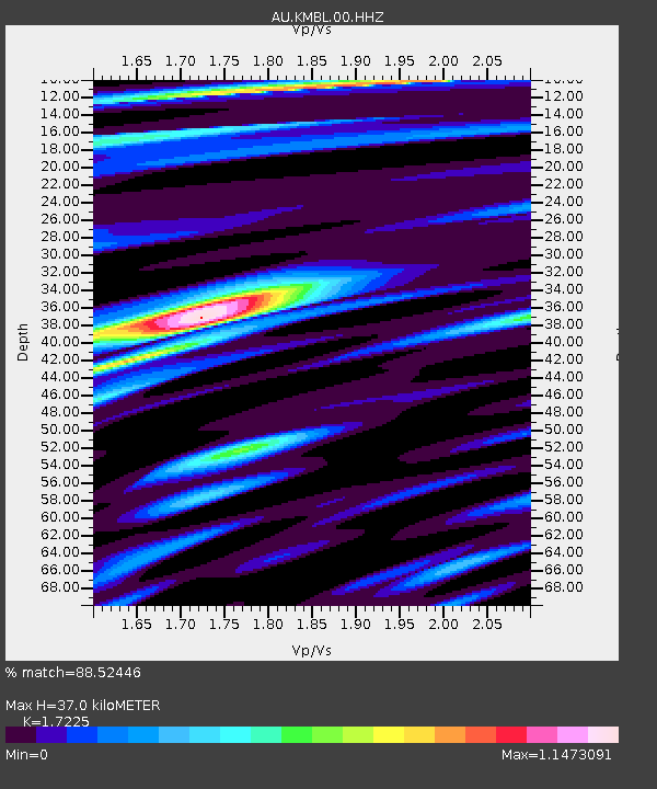
| Estimated Moho Depth: |
37.0 km |
| Estimated Crust Vp/Vs: |
1.72 |
| Assumed Crust Vp: |
6.459 km/s |
| Estimated Crust Vs: |
3.75 km/s |
| Estimated Crust Poisson's Ratio: |
0.25 |
|
| Radial Match: |
88.52446 % |
| Radial Bump: |
291 |
| Transverse Match: |
64.18967 % |
| Transverse Bump: |
400 |
| SOD ConfigId: |
29823551 |
| Insert Time: |
2023-03-15 05:41:12.355 +0000 |
| GWidth: |
2.5 |
| Max Bumps: |
400 |
| Tol: |
0.001 |
|

Signal To Noise
| Channel | StoN | STA | LTA |
| AU:KMBL:00:HHZ:20230301T05:42:05.445007Z | 27.220327 | 3.4958537E-6 | 1.2842806E-7 |
| AU:KMBL:00:HHN:20230301T05:42:05.445007Z | 19.288456 | 1.3366662E-6 | 6.9298764E-8 |
| AU:KMBL:00:HHE:20230301T05:42:05.445007Z | 26.722471 | 1.7190348E-6 | 6.4329186E-8 |
| Arrivals |
| Ps | 4.4 SECOND |
| PpPs | 15 SECOND |
| PsPs/PpSs | 19 SECOND |


