You are here: Home > Network List > AU - Australian Seismological Centre Stations List
> Station MORW Morawa, Western Australia > Earthquake Result Viewer
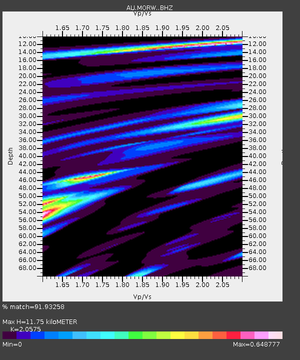
MORW Morawa, Western Australia - Earthquake Result Viewer
| Earthquake location: |
Bismarck Sea |
| Earthquake latitude/longitude: |
-4.8/149.6 |
| Earthquake time(UTC): |
2023/03/01 (060) 05:36:14 GMT |
| Earthquake Depth: |
583 km |
| Earthquake Magnitude: |
6.5 Mi |
| Earthquake Catalog/Contributor: |
NEIC PDE/at |
|
| Network: |
AU Australian Seismological Centre |
| Station: |
MORW Morawa, Western Australia |
| Lat/Lon: |
29.07 S/116.04 E |
| Elevation: |
296 m |
|
| Distance: |
39.9 deg |
| Az: |
228.976 deg |
| Baz: |
59.183 deg |
| Ray Param: |
0.07172549 |
| Estimated Moho Depth: |
11.75 km |
| Estimated Crust Vp/Vs: |
2.06 |
| Assumed Crust Vp: |
6.459 km/s |
| Estimated Crust Vs: |
3.139 km/s |
| Estimated Crust Poisson's Ratio: |
0.35 |
|
| Radial Match: |
91.93258 % |
| Radial Bump: |
246 |
| Transverse Match: |
67.72343 % |
| Transverse Bump: |
400 |
| SOD ConfigId: |
29823551 |
| Insert Time: |
2023-03-15 05:41:20.253 +0000 |
| GWidth: |
2.5 |
| Max Bumps: |
400 |
| Tol: |
0.001 |
|

Signal To Noise
| Channel | StoN | STA | LTA |
| AU:MORW: :BHZ:20230301T05:42:28.069Z | 40.97116 | 6.42158E-6 | 1.5673415E-7 |
| AU:MORW: :BHN:20230301T05:42:28.069Z | 13.406893 | 1.9668091E-6 | 1.4670132E-7 |
| AU:MORW: :BHE:20230301T05:42:28.069Z | 20.357273 | 3.102491E-6 | 1.5240208E-7 |
| Arrivals |
| Ps | 2.0 SECOND |
| PpPs | 5.3 SECOND |
| PsPs/PpSs | 7.3 SECOND |


