You are here: Home > Network List > AV - Alaska Volcano Observatory Stations List
> Station AMKA Regional Station, Amchitka Island, Alaska > Earthquake Result Viewer
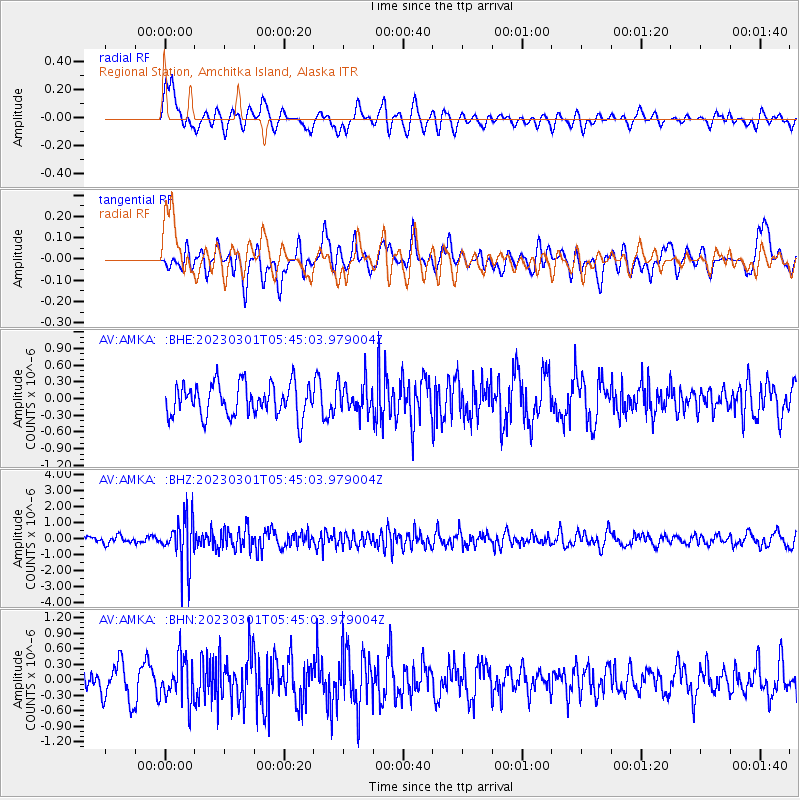
AMKA Regional Station, Amchitka Island, Alaska - Earthquake Result Viewer
*The percent match for this event was below the threshold and hence no stack was calculated.
| Earthquake location: |
Bismarck Sea |
| Earthquake latitude/longitude: |
-4.8/149.6 |
| Earthquake time(UTC): |
2023/03/01 (060) 05:36:14 GMT |
| Earthquake Depth: |
583 km |
| Earthquake Magnitude: |
6.5 Mi |
| Earthquake Catalog/Contributor: |
NEIC PDE/at |
|
| Network: |
AV Alaska Volcano Observatory |
| Station: |
AMKA Regional Station, Amchitka Island, Alaska |
| Lat/Lon: |
51.38 N/179.30 E |
| Elevation: |
116 m |
|
| Distance: |
61.5 deg |
| Az: |
20.701 deg |
| Baz: |
214.198 deg |
| Ray Param: |
$rayparam |
*The percent match for this event was below the threshold and hence was not used in the summary stack. |
|
| Radial Match: |
44.884827 % |
| Radial Bump: |
400 |
| Transverse Match: |
44.293964 % |
| Transverse Bump: |
400 |
| SOD ConfigId: |
29823551 |
| Insert Time: |
2023-03-15 05:42:05.886 +0000 |
| GWidth: |
2.5 |
| Max Bumps: |
400 |
| Tol: |
0.001 |
|
Signal To Noise
| Channel | StoN | STA | LTA |
| AV:AMKA: :BHZ:20230301T05:45:03.979004Z | 5.2447743 | 1.50612E-6 | 2.8716585E-7 |
| AV:AMKA: :BHN:20230301T05:45:03.979004Z | 1.2705231 | 4.1658217E-7 | 3.2788242E-7 |
| AV:AMKA: :BHE:20230301T05:45:03.979004Z | 0.9486228 | 2.7412628E-7 | 2.889729E-7 |
| Arrivals |
| Ps | |
| PpPs | |
| PsPs/PpSs | |


