You are here: Home > Network List > TM - Thai Seismic Monitoring Network Stations List
> Station LOEI Nam Man, Loei > Earthquake Result Viewer
LOEI Nam Man, Loei - Earthquake Result Viewer
| Earthquake location: |
Bismarck Sea |
| Earthquake latitude/longitude: |
-4.8/149.6 |
| Earthquake time(UTC): |
2023/03/01 (060) 05:36:14 GMT |
| Earthquake Depth: |
583 km |
| Earthquake Magnitude: |
6.5 Mi |
| Earthquake Catalog/Contributor: |
NEIC PDE/at |
|
| Network: |
TM Thai Seismic Monitoring Network |
| Station: |
LOEI Nam Man, Loei |
| Lat/Lon: |
17.51 N/101.62 E |
| Elevation: |
305 m |
|
| Distance: |
52.3 deg |
| Az: |
296.348 deg |
| Baz: |
110.637 deg |
| Ray Param: |
0.06424419 |
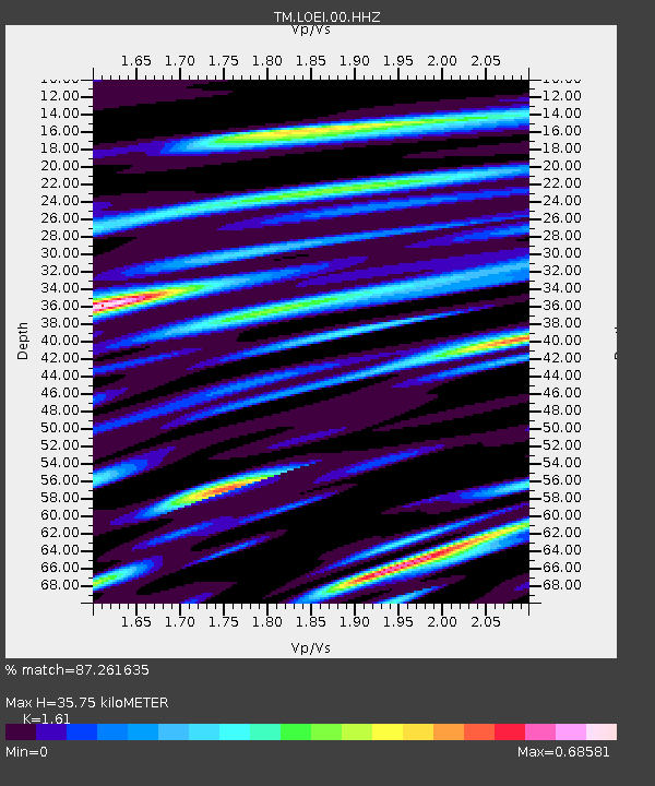
| Estimated Moho Depth: |
35.75 km |
| Estimated Crust Vp/Vs: |
1.61 |
| Assumed Crust Vp: |
6.35 km/s |
| Estimated Crust Vs: |
3.944 km/s |
| Estimated Crust Poisson's Ratio: |
0.19 |
|
| Radial Match: |
87.261635 % |
| Radial Bump: |
390 |
| Transverse Match: |
78.40052 % |
| Transverse Bump: |
400 |
| SOD ConfigId: |
29823551 |
| Insert Time: |
2023-03-15 05:54:41.274 +0000 |
| GWidth: |
2.5 |
| Max Bumps: |
400 |
| Tol: |
0.001 |
|

Signal To Noise
| Channel | StoN | STA | LTA |
| TM:LOEI:00:HHZ:20230301T05:44:01.48999Z | 47.204647 | 4.1613025E-6 | 8.815451E-8 |
| TM:LOEI:00:HHN:20230301T05:44:01.48999Z | 5.843443 | 4.4095086E-7 | 7.54608E-8 |
| TM:LOEI:00:HHE:20230301T05:44:01.48999Z | 21.158255 | 1.8277758E-6 | 8.638594E-8 |
| Arrivals |
| Ps | 3.6 SECOND |
| PpPs | 14 SECOND |
| PsPs/PpSs | 18 SECOND |


