You are here: Home > Network List > GS - US Geological Survey Networks Stations List
> Station KAN16 SW of Harper, Kansas - Bergman residence > Earthquake Result Viewer
KAN16 SW of Harper, Kansas - Bergman residence - Earthquake Result Viewer
| Earthquake location: |
Fiji Islands Region |
| Earthquake latitude/longitude: |
-18.0/-178.1 |
| Earthquake time(UTC): |
2018/09/26 (269) 00:37:33 GMT |
| Earthquake Depth: |
569 km |
| Earthquake Magnitude: |
5.8 Mwb |
| Earthquake Catalog/Contributor: |
NEIC PDE/us |
|
| Network: |
GS US Geological Survey Networks |
| Station: |
KAN16 SW of Harper, Kansas - Bergman residence |
| Lat/Lon: |
37.23 N/98.06 W |
| Elevation: |
435 m |
|
| Distance: |
93.1 deg |
| Az: |
51.936 deg |
| Baz: |
249.816 deg |
| Ray Param: |
0.040843345 |
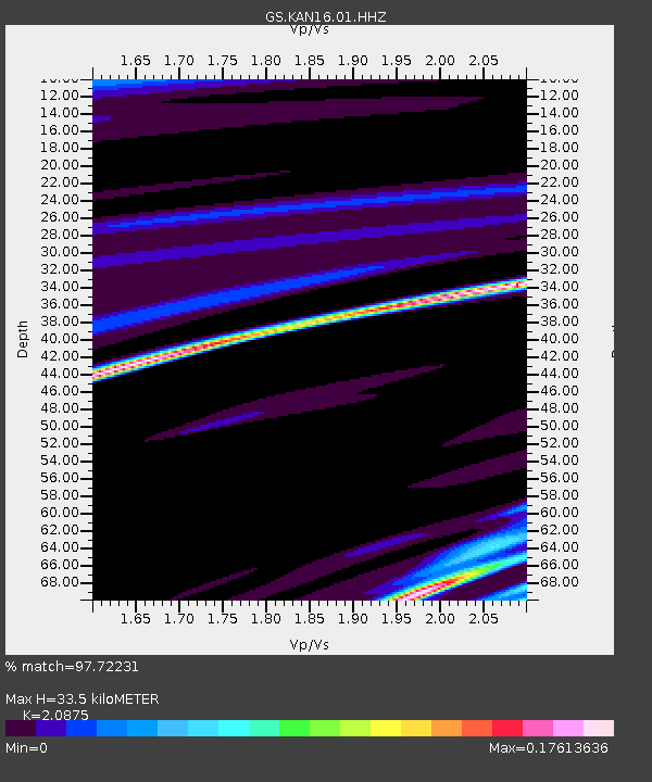
| Estimated Moho Depth: |
33.5 km |
| Estimated Crust Vp/Vs: |
2.09 |
| Assumed Crust Vp: |
6.426 km/s |
| Estimated Crust Vs: |
3.078 km/s |
| Estimated Crust Poisson's Ratio: |
0.35 |
|
| Radial Match: |
97.72231 % |
| Radial Bump: |
52 |
| Transverse Match: |
84.89081 % |
| Transverse Bump: |
141 |
| SOD ConfigId: |
3045211 |
| Insert Time: |
2018-10-10 00:43:17.309 +0000 |
| GWidth: |
2.5 |
| Max Bumps: |
400 |
| Tol: |
0.001 |
|

Signal To Noise
| Channel | StoN | STA | LTA |
| GS:KAN16:01:HHZ:20180926T00:49:15.30501Z | 3.9889474 | 2.801236E-8 | 7.0224946E-9 |
| GS:KAN16:01:HHN:20180926T00:49:15.30501Z | 3.214734 | 2.2697666E-8 | 7.0605113E-9 |
| GS:KAN16:01:HHE:20180926T00:49:15.30501Z | 3.5619736 | 3.1918358E-8 | 8.960863E-9 |
| Arrivals |
| Ps | 5.8 SECOND |
| PpPs | 16 SECOND |
| PsPs/PpSs | 22 SECOND |


