You are here: Home > Network List > US - United States National Seismic Network Stations List
> Station MNTX Cornudas Mountains, Texas, USA > Earthquake Result Viewer
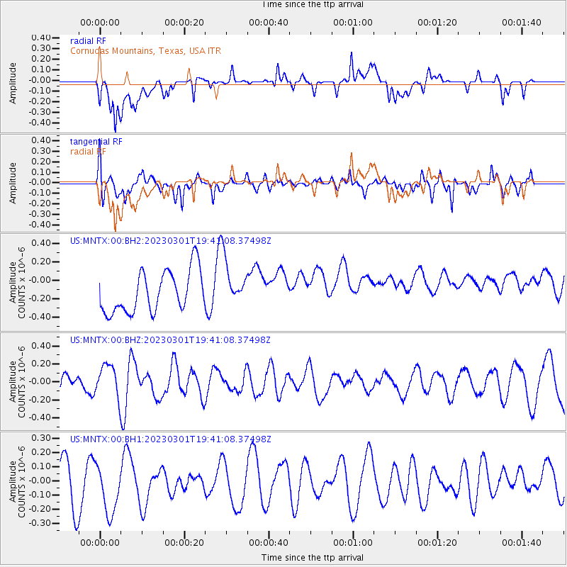
MNTX Cornudas Mountains, Texas, USA - Earthquake Result Viewer
*The percent match for this event was below the threshold and hence no stack was calculated.
| Earthquake location: |
Mariana Islands |
| Earthquake latitude/longitude: |
14.1/146.8 |
| Earthquake time(UTC): |
2023/03/01 (060) 19:28:07 GMT |
| Earthquake Depth: |
9.9 km |
| Earthquake Magnitude: |
5.5 Mww |
| Earthquake Catalog/Contributor: |
NEIC PDE/us |
|
| Network: |
US United States National Seismic Network |
| Station: |
MNTX Cornudas Mountains, Texas, USA |
| Lat/Lon: |
31.70 N/105.38 W |
| Elevation: |
405 m |
|
| Distance: |
97.2 deg |
| Az: |
54.889 deg |
| Baz: |
291.416 deg |
| Ray Param: |
$rayparam |
*The percent match for this event was below the threshold and hence was not used in the summary stack. |
|
| Radial Match: |
42.287712 % |
| Radial Bump: |
400 |
| Transverse Match: |
62.206886 % |
| Transverse Bump: |
400 |
| SOD ConfigId: |
30536071 |
| Insert Time: |
2023-03-15 19:44:16.495 +0000 |
| GWidth: |
2.5 |
| Max Bumps: |
400 |
| Tol: |
0.001 |
|
Signal To Noise
| Channel | StoN | STA | LTA |
| US:MNTX:00:BHZ:20230301T19:41:08.37498Z | 0.74452156 | 1.8019738E-7 | 2.420311E-7 |
| US:MNTX:00:BH1:20230301T19:41:08.37498Z | 1.1791558 | 2.129776E-7 | 1.8061871E-7 |
| US:MNTX:00:BH2:20230301T19:41:08.37498Z | 1.0614234 | 2.4089758E-7 | 2.2695708E-7 |
| Arrivals |
| Ps | |
| PpPs | |
| PsPs/PpSs | |


