You are here: Home > Network List > CI - Caltech Regional Seismic Network Stations List
> Station LRL Laurel Mtn Radio Fac, Ridgecrest, CA, USA > Earthquake Result Viewer
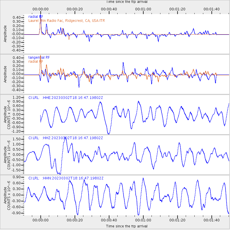
LRL Laurel Mtn Radio Fac, Ridgecrest, CA, USA - Earthquake Result Viewer
*The percent match for this event was below the threshold and hence no stack was calculated.
| Earthquake location: |
Vanuatu Islands |
| Earthquake latitude/longitude: |
-15.4/166.4 |
| Earthquake time(UTC): |
2023/03/02 (061) 18:04:29 GMT |
| Earthquake Depth: |
10 km |
| Earthquake Magnitude: |
6.5 Mww |
| Earthquake Catalog/Contributor: |
NEIC PDE/us |
|
| Network: |
CI Caltech Regional Seismic Network |
| Station: |
LRL Laurel Mtn Radio Fac, Ridgecrest, CA, USA |
| Lat/Lon: |
35.48 N/117.68 W |
| Elevation: |
1340 m |
|
| Distance: |
87.8 deg |
| Az: |
52.405 deg |
| Baz: |
249.449 deg |
| Ray Param: |
$rayparam |
*The percent match for this event was below the threshold and hence was not used in the summary stack. |
|
| Radial Match: |
51.27101 % |
| Radial Bump: |
284 |
| Transverse Match: |
78.56574 % |
| Transverse Bump: |
400 |
| SOD ConfigId: |
30536071 |
| Insert Time: |
2023-03-16 18:14:04.311 +0000 |
| GWidth: |
2.5 |
| Max Bumps: |
400 |
| Tol: |
0.001 |
|
Signal To Noise
| Channel | StoN | STA | LTA |
| CI:LRL: :HHZ:20230302T18:16:47.19802Z | 2.2619112 | 7.740836E-7 | 3.4222546E-7 |
| CI:LRL: :HHN:20230302T18:16:47.19802Z | 0.9288656 | 2.740408E-7 | 2.9502735E-7 |
| CI:LRL: :HHE:20230302T18:16:47.19802Z | 1.0404487 | 4.2487693E-7 | 4.083593E-7 |
| Arrivals |
| Ps | |
| PpPs | |
| PsPs/PpSs | |


