You are here: Home > Network List > UU - University of Utah Regional Network Stations List
> Station MOUT Mount Ogden, UT, USA > Earthquake Result Viewer
MOUT Mount Ogden, UT, USA - Earthquake Result Viewer
| Earthquake location: |
Vanuatu Islands |
| Earthquake latitude/longitude: |
-15.4/166.4 |
| Earthquake time(UTC): |
2023/03/02 (061) 18:04:29 GMT |
| Earthquake Depth: |
10 km |
| Earthquake Magnitude: |
6.5 Mww |
| Earthquake Catalog/Contributor: |
NEIC PDE/us |
|
| Network: |
UU University of Utah Regional Network |
| Station: |
MOUT Mount Ogden, UT, USA |
| Lat/Lon: |
41.20 N/111.88 W |
| Elevation: |
2748 m |
|
| Distance: |
93.9 deg |
| Az: |
48.469 deg |
| Baz: |
253.1 deg |
| Ray Param: |
0.04115686 |
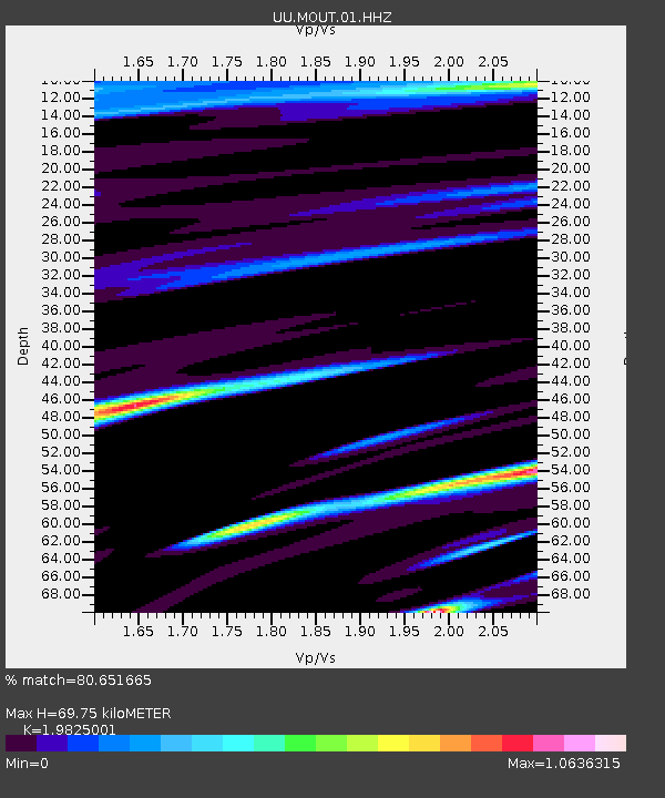
| Estimated Moho Depth: |
69.75 km |
| Estimated Crust Vp/Vs: |
1.98 |
| Assumed Crust Vp: |
6.155 km/s |
| Estimated Crust Vs: |
3.105 km/s |
| Estimated Crust Poisson's Ratio: |
0.33 |
|
| Radial Match: |
80.651665 % |
| Radial Bump: |
400 |
| Transverse Match: |
57.2683 % |
| Transverse Bump: |
400 |
| SOD ConfigId: |
30536071 |
| Insert Time: |
2023-03-16 18:22:15.196 +0000 |
| GWidth: |
2.5 |
| Max Bumps: |
400 |
| Tol: |
0.001 |
|

Signal To Noise
| Channel | StoN | STA | LTA |
| UU:MOUT:01:HHZ:20230302T18:17:15.750022Z | 2.5921578 | 7.8235354E-7 | 3.0181553E-7 |
| UU:MOUT:01:HHN:20230302T18:17:15.750022Z | 1.1563406 | 4.70165E-7 | 4.0659734E-7 |
| UU:MOUT:01:HHE:20230302T18:17:15.750022Z | 0.6869146 | 2.9471494E-7 | 4.290416E-7 |
| Arrivals |
| Ps | 11 SECOND |
| PpPs | 33 SECOND |
| PsPs/PpSs | 45 SECOND |


