You are here: Home > Network List > UW - Pacific Northwest Regional Seismic Network Stations List
> Station HOOD Mt Hood Meadows, OR CREST BB SMO > Earthquake Result Viewer
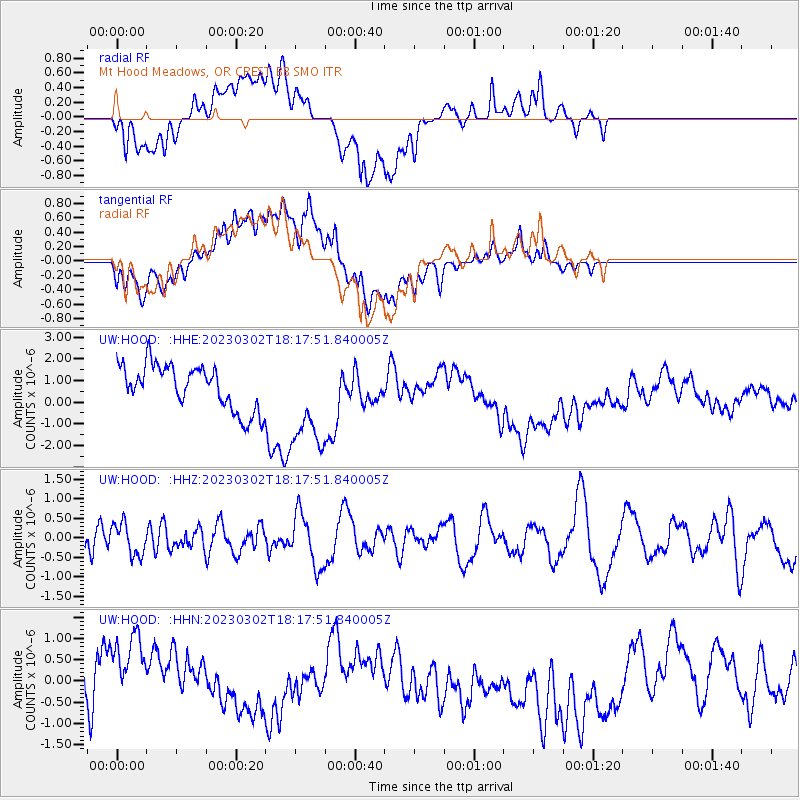
HOOD Mt Hood Meadows, OR CREST BB SMO - Earthquake Result Viewer
*The percent match for this event was below the threshold and hence no stack was calculated.
| Earthquake location: |
Vanuatu Islands |
| Earthquake latitude/longitude: |
-15.0/166.6 |
| Earthquake time(UTC): |
2023/03/02 (061) 18:05:31 GMT |
| Earthquake Depth: |
10 km |
| Earthquake Magnitude: |
5.7 mb |
| Earthquake Catalog/Contributor: |
NEIC PDE/us |
|
| Network: |
UW Pacific Northwest Regional Seismic Network |
| Station: |
HOOD Mt Hood Meadows, OR CREST BB SMO |
| Lat/Lon: |
45.32 N/121.65 W |
| Elevation: |
1520 m |
|
| Distance: |
88.3 deg |
| Az: |
42.099 deg |
| Baz: |
246.648 deg |
| Ray Param: |
$rayparam |
*The percent match for this event was below the threshold and hence was not used in the summary stack. |
|
| Radial Match: |
54.55219 % |
| Radial Bump: |
400 |
| Transverse Match: |
53.19817 % |
| Transverse Bump: |
400 |
| SOD ConfigId: |
30536071 |
| Insert Time: |
2023-03-16 18:39:10.394 +0000 |
| GWidth: |
2.5 |
| Max Bumps: |
400 |
| Tol: |
0.001 |
|
Signal To Noise
| Channel | StoN | STA | LTA |
| UW:HOOD: :HHZ:20230302T18:17:51.840005Z | 0.58107686 | 4.1052274E-7 | 7.0648616E-7 |
| UW:HOOD: :HHN:20230302T18:17:51.840005Z | 1.50481 | 1.2795576E-6 | 8.503118E-7 |
| UW:HOOD: :HHE:20230302T18:17:51.840005Z | 2.188458 | 2.248685E-6 | 1.0275204E-6 |
| Arrivals |
| Ps | |
| PpPs | |
| PsPs/PpSs | |


