You are here: Home > Network List > UW - Pacific Northwest Regional Seismic Network Stations List
> Station IRON Crane, OR, USA > Earthquake Result Viewer
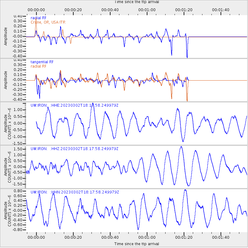
IRON Crane, OR, USA - Earthquake Result Viewer
*The percent match for this event was below the threshold and hence no stack was calculated.
| Earthquake location: |
Vanuatu Islands |
| Earthquake latitude/longitude: |
-15.0/166.6 |
| Earthquake time(UTC): |
2023/03/02 (061) 18:05:31 GMT |
| Earthquake Depth: |
10 km |
| Earthquake Magnitude: |
5.7 mb |
| Earthquake Catalog/Contributor: |
NEIC PDE/us |
|
| Network: |
UW Pacific Northwest Regional Seismic Network |
| Station: |
IRON Crane, OR, USA |
| Lat/Lon: |
43.36 N/118.47 W |
| Elevation: |
1226 m |
|
| Distance: |
89.6 deg |
| Az: |
44.779 deg |
| Baz: |
248.912 deg |
| Ray Param: |
$rayparam |
*The percent match for this event was below the threshold and hence was not used in the summary stack. |
|
| Radial Match: |
72.49899 % |
| Radial Bump: |
330 |
| Transverse Match: |
81.743416 % |
| Transverse Bump: |
363 |
| SOD ConfigId: |
30536071 |
| Insert Time: |
2023-03-16 18:39:15.211 +0000 |
| GWidth: |
2.5 |
| Max Bumps: |
400 |
| Tol: |
0.001 |
|
Signal To Noise
| Channel | StoN | STA | LTA |
| UW:IRON: :HHZ:20230302T18:17:58.249979Z | 0.26584858 | 1.7335378E-7 | 6.520772E-7 |
| UW:IRON: :HHN:20230302T18:17:58.249979Z | 1.4365865 | 3.8786737E-7 | 2.6999234E-7 |
| UW:IRON: :HHE:20230302T18:17:58.249979Z | 1.6570504 | 9.427942E-7 | 5.6895925E-7 |
| Arrivals |
| Ps | |
| PpPs | |
| PsPs/PpSs | |


