You are here: Home > Network List > AE - Arizona Broadband Seismic Network Stations List
> Station W18A Petrified Forest, AZ, USA > Earthquake Result Viewer
W18A Petrified Forest, AZ, USA - Earthquake Result Viewer
| Earthquake location: |
Kermadec Islands, New Zealand |
| Earthquake latitude/longitude: |
-29.5/-178.8 |
| Earthquake time(UTC): |
2023/03/04 (063) 06:41:22 GMT |
| Earthquake Depth: |
206 km |
| Earthquake Magnitude: |
6.9 mww |
| Earthquake Catalog/Contributor: |
NEIC PDE/us |
|
| Network: |
AE Arizona Broadband Seismic Network |
| Station: |
W18A Petrified Forest, AZ, USA |
| Lat/Lon: |
35.12 N/109.74 W |
| Elevation: |
1750 m |
|
| Distance: |
91.4 deg |
| Az: |
49.981 deg |
| Baz: |
234.548 deg |
| Ray Param: |
0.041521307 |
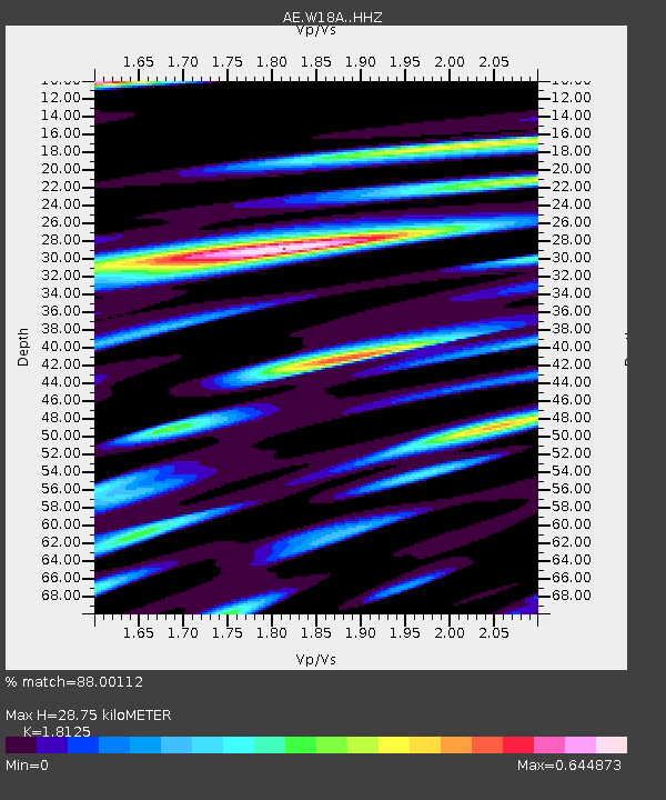
| Estimated Moho Depth: |
28.75 km |
| Estimated Crust Vp/Vs: |
1.81 |
| Assumed Crust Vp: |
6.496 km/s |
| Estimated Crust Vs: |
3.584 km/s |
| Estimated Crust Poisson's Ratio: |
0.28 |
|
| Radial Match: |
88.00112 % |
| Radial Bump: |
400 |
| Transverse Match: |
68.932976 % |
| Transverse Bump: |
400 |
| SOD ConfigId: |
30536071 |
| Insert Time: |
2023-03-18 06:42:11.498 +0000 |
| GWidth: |
2.5 |
| Max Bumps: |
400 |
| Tol: |
0.001 |
|

Signal To Noise
| Channel | StoN | STA | LTA |
| AE:W18A: :HHZ:20230304T06:53:33.62901Z | 22.206758 | 3.710394E-6 | 1.67084E-7 |
| AE:W18A: :HHN:20230304T06:53:33.62901Z | 3.4570956 | 8.840002E-7 | 2.5570603E-7 |
| AE:W18A: :HHE:20230304T06:53:33.62901Z | 7.4394593 | 1.0617031E-6 | 1.4271241E-7 |
| Arrivals |
| Ps | 3.7 SECOND |
| PpPs | 12 SECOND |
| PsPs/PpSs | 16 SECOND |


