You are here: Home > Network List > GS - US Geological Survey Networks Stations List
> Station OK051 E0350 and S34600 Roads, Ralston, OK > Earthquake Result Viewer
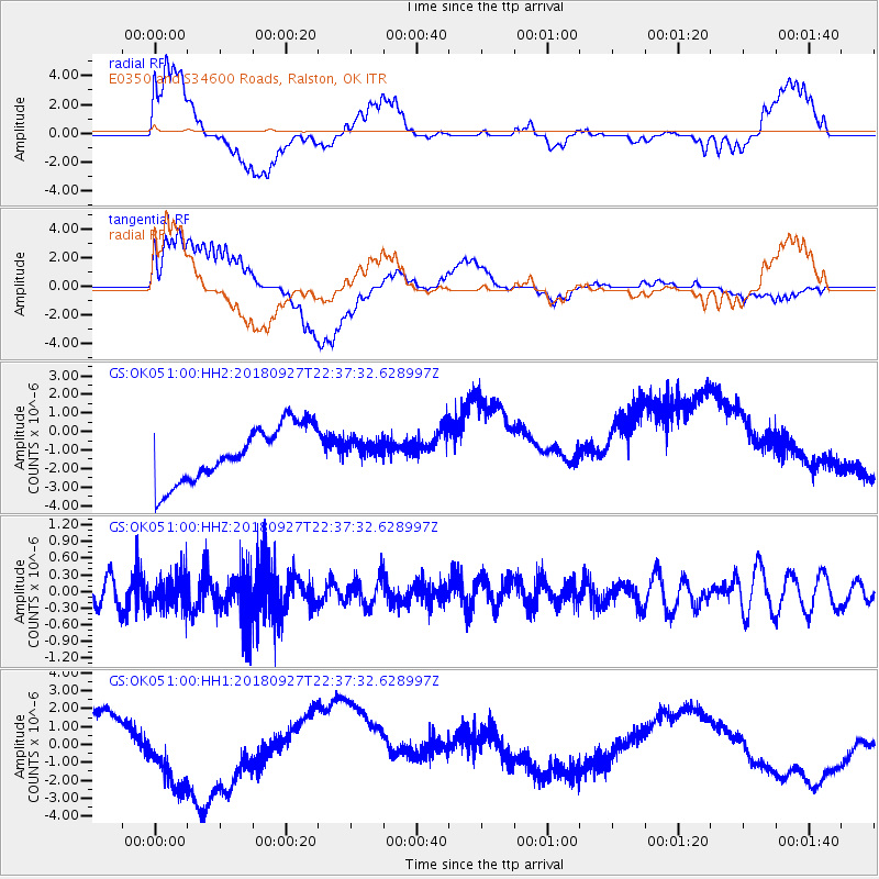
OK051 E0350 and S34600 Roads, Ralston, OK - Earthquake Result Viewer
*The percent match for this event was below the threshold and hence no stack was calculated.
| Earthquake location: |
Fiji Islands Region |
| Earthquake latitude/longitude: |
-18.2/-178.2 |
| Earthquake time(UTC): |
2018/09/27 (270) 22:25:43 GMT |
| Earthquake Depth: |
540 km |
| Earthquake Magnitude: |
5.5 Mww |
| Earthquake Catalog/Contributor: |
NEIC PDE/us |
|
| Network: |
GS US Geological Survey Networks |
| Station: |
OK051 E0350 and S34600 Roads, Ralston, OK |
| Lat/Lon: |
36.51 N/96.84 W |
| Elevation: |
263 m |
|
| Distance: |
94.0 deg |
| Az: |
52.994 deg |
| Baz: |
250.451 deg |
| Ray Param: |
$rayparam |
*The percent match for this event was below the threshold and hence was not used in the summary stack. |
|
| Radial Match: |
49.31355 % |
| Radial Bump: |
400 |
| Transverse Match: |
53.206326 % |
| Transverse Bump: |
400 |
| SOD ConfigId: |
3045211 |
| Insert Time: |
2018-10-11 22:28:35.160 +0000 |
| GWidth: |
2.5 |
| Max Bumps: |
400 |
| Tol: |
0.001 |
|
Signal To Noise
| Channel | StoN | STA | LTA |
| GS:OK051:00:HHZ:20180927T22:37:32.628997Z | 1.2421592 | 3.1581175E-7 | 2.5424416E-7 |
| GS:OK051:00:HH1:20180927T22:37:32.628997Z | 1.2300856 | 2.0239438E-6 | 1.6453682E-6 |
| GS:OK051:00:HH2:20180927T22:37:32.628997Z | 0.38120714 | 5.6877735E-7 | 1.4920427E-6 |
| Arrivals |
| Ps | |
| PpPs | |
| PsPs/PpSs | |


