You are here: Home > Network List > IW - Intermountain West Stations List
> Station MOOW Moose Ponds, Wyoming, USA > Earthquake Result Viewer
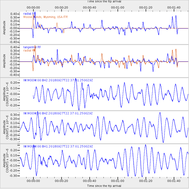
MOOW Moose Ponds, Wyoming, USA - Earthquake Result Viewer
*The percent match for this event was below the threshold and hence no stack was calculated.
| Earthquake location: |
Fiji Islands Region |
| Earthquake latitude/longitude: |
-18.2/-178.2 |
| Earthquake time(UTC): |
2018/09/27 (270) 22:25:43 GMT |
| Earthquake Depth: |
540 km |
| Earthquake Magnitude: |
5.5 Mww |
| Earthquake Catalog/Contributor: |
NEIC PDE/us |
|
| Network: |
IW Intermountain West |
| Station: |
MOOW Moose Ponds, Wyoming, USA |
| Lat/Lon: |
43.75 N/110.74 W |
| Elevation: |
2128 m |
|
| Distance: |
87.1 deg |
| Az: |
42.095 deg |
| Baz: |
241.582 deg |
| Ray Param: |
$rayparam |
*The percent match for this event was below the threshold and hence was not used in the summary stack. |
|
| Radial Match: |
52.401073 % |
| Radial Bump: |
400 |
| Transverse Match: |
52.49957 % |
| Transverse Bump: |
400 |
| SOD ConfigId: |
3045211 |
| Insert Time: |
2018-10-11 22:29:22.111 +0000 |
| GWidth: |
2.5 |
| Max Bumps: |
400 |
| Tol: |
0.001 |
|
Signal To Noise
| Channel | StoN | STA | LTA |
| IW:MOOW:00:BHZ:20180927T22:37:01.250029Z | 2.1398678 | 2.0522276E-7 | 9.590441E-8 |
| IW:MOOW:00:BH1:20180927T22:37:01.250029Z | 2.3403573 | 1.8613335E-7 | 7.953202E-8 |
| IW:MOOW:00:BH2:20180927T22:37:01.250029Z | 2.262193 | 1.9147657E-7 | 8.464202E-8 |
| Arrivals |
| Ps | |
| PpPs | |
| PsPs/PpSs | |


