You are here: Home > Network List > AU - Australian Seismological Centre Stations List
> Station MUN Mundaring, Western Australia > Earthquake Result Viewer
MUN Mundaring, Western Australia - Earthquake Result Viewer
| Earthquake location: |
Kermadec Islands, New Zealand |
| Earthquake latitude/longitude: |
-29.5/-178.8 |
| Earthquake time(UTC): |
2023/03/04 (063) 06:41:22 GMT |
| Earthquake Depth: |
206 km |
| Earthquake Magnitude: |
6.9 mww |
| Earthquake Catalog/Contributor: |
NEIC PDE/us |
|
| Network: |
AU Australian Seismological Centre |
| Station: |
MUN Mundaring, Western Australia |
| Lat/Lon: |
31.98 S/116.21 E |
| Elevation: |
253 m |
|
| Distance: |
55.2 deg |
| Az: |
249.775 deg |
| Baz: |
105.679 deg |
| Ray Param: |
0.06427323 |
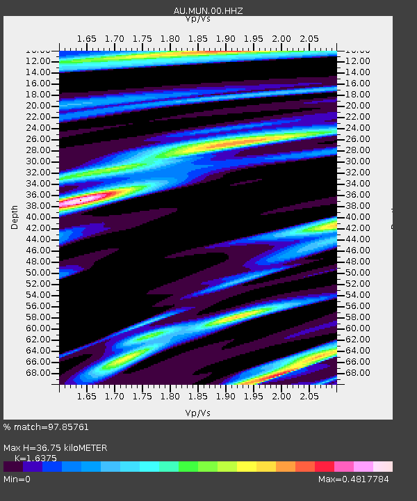
| Estimated Moho Depth: |
36.75 km |
| Estimated Crust Vp/Vs: |
1.64 |
| Assumed Crust Vp: |
6.419 km/s |
| Estimated Crust Vs: |
3.92 km/s |
| Estimated Crust Poisson's Ratio: |
0.20 |
|
| Radial Match: |
97.85761 % |
| Radial Bump: |
235 |
| Transverse Match: |
86.98504 % |
| Transverse Bump: |
400 |
| SOD ConfigId: |
30536071 |
| Insert Time: |
2023-03-18 06:46:11.152 +0000 |
| GWidth: |
2.5 |
| Max Bumps: |
400 |
| Tol: |
0.001 |
|

Signal To Noise
| Channel | StoN | STA | LTA |
| AU:MUN:00:HHZ:20230304T06:50:02.824994Z | 11.6478 | 3.6169597E-6 | 3.1052727E-7 |
| AU:MUN:00:HHN:20230304T06:50:02.824994Z | 3.7683313 | 6.752897E-7 | 1.7920125E-7 |
| AU:MUN:00:HHE:20230304T06:50:02.824994Z | 10.610109 | 1.7462081E-6 | 1.6457965E-7 |
| Arrivals |
| Ps | 3.9 SECOND |
| PpPs | 14 SECOND |
| PsPs/PpSs | 18 SECOND |


