You are here: Home > Network List > AV - Alaska Volcano Observatory Stations List
> Station AHB Akutan Harbor, Akutan Volcano, Alaska > Earthquake Result Viewer
AHB Akutan Harbor, Akutan Volcano, Alaska - Earthquake Result Viewer
| Earthquake location: |
Kermadec Islands, New Zealand |
| Earthquake latitude/longitude: |
-29.5/-178.8 |
| Earthquake time(UTC): |
2023/03/04 (063) 06:41:22 GMT |
| Earthquake Depth: |
206 km |
| Earthquake Magnitude: |
6.9 mww |
| Earthquake Catalog/Contributor: |
NEIC PDE/us |
|
| Network: |
AV Alaska Volcano Observatory |
| Station: |
AHB Akutan Harbor, Akutan Volcano, Alaska |
| Lat/Lon: |
54.11 N/165.82 W |
| Elevation: |
447 m |
|
| Distance: |
84.0 deg |
| Az: |
7.635 deg |
| Baz: |
191.349 deg |
| Ray Param: |
0.045303874 |
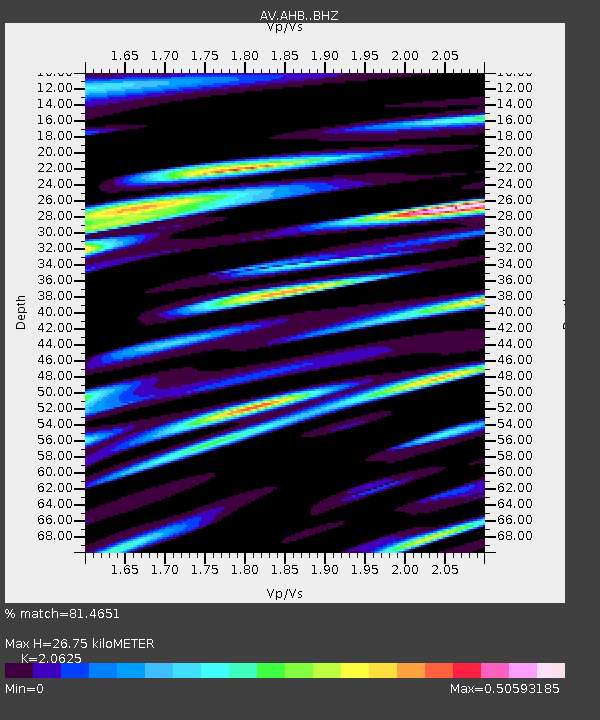
| Estimated Moho Depth: |
26.75 km |
| Estimated Crust Vp/Vs: |
2.06 |
| Assumed Crust Vp: |
5.989 km/s |
| Estimated Crust Vs: |
2.904 km/s |
| Estimated Crust Poisson's Ratio: |
0.35 |
|
| Radial Match: |
81.4651 % |
| Radial Bump: |
400 |
| Transverse Match: |
78.51667 % |
| Transverse Bump: |
400 |
| SOD ConfigId: |
30536071 |
| Insert Time: |
2023-03-18 06:46:47.185 +0000 |
| GWidth: |
2.5 |
| Max Bumps: |
400 |
| Tol: |
0.001 |
|

Signal To Noise
| Channel | StoN | STA | LTA |
| AV:AHB: :BHZ:20230304T06:52:58.278973Z | 7.817714 | 1.0826749E-5 | 1.3848994E-6 |
| AV:AHB: :BHN:20230304T06:52:58.278973Z | 3.062082 | 4.8567467E-6 | 1.5860929E-6 |
| AV:AHB: :BHE:20230304T06:52:58.278973Z | 2.863059 | 3.7151515E-6 | 1.2976161E-6 |
| Arrivals |
| Ps | 4.8 SECOND |
| PpPs | 13 SECOND |
| PsPs/PpSs | 18 SECOND |


