You are here: Home > Network List > SB - UC Santa Barbara Engineering Seismology Network () Stations List
> Station VAFB1 Globe Rd, Vandenberg AFB, CA, USA > Earthquake Result Viewer
VAFB1 Globe Rd, Vandenberg AFB, CA, USA - Earthquake Result Viewer
| Earthquake location: |
Kermadec Islands, New Zealand |
| Earthquake latitude/longitude: |
-29.5/-178.8 |
| Earthquake time(UTC): |
2023/03/04 (063) 06:41:22 GMT |
| Earthquake Depth: |
206 km |
| Earthquake Magnitude: |
6.9 mww |
| Earthquake Catalog/Contributor: |
NEIC PDE/us |
|
| Network: |
SB UC Santa Barbara Engineering Seismology Network () |
| Station: |
VAFB1 Globe Rd, Vandenberg AFB, CA, USA |
| Lat/Lon: |
34.86 N/120.60 W |
| Elevation: |
121 m |
|
| Distance: |
84.3 deg |
| Az: |
44.614 deg |
| Baz: |
228.133 deg |
| Ray Param: |
0.045093916 |
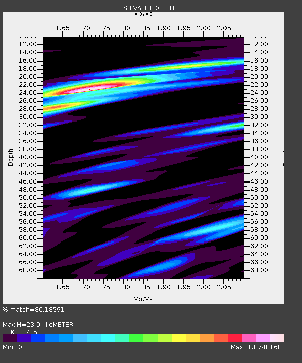
| Estimated Moho Depth: |
23.0 km |
| Estimated Crust Vp/Vs: |
1.72 |
| Assumed Crust Vp: |
6.183 km/s |
| Estimated Crust Vs: |
3.605 km/s |
| Estimated Crust Poisson's Ratio: |
0.24 |
|
| Radial Match: |
80.18591 % |
| Radial Bump: |
400 |
| Transverse Match: |
61.60352 % |
| Transverse Bump: |
400 |
| SOD ConfigId: |
30536071 |
| Insert Time: |
2023-03-18 07:04:50.412 +0000 |
| GWidth: |
2.5 |
| Max Bumps: |
400 |
| Tol: |
0.001 |
|

Signal To Noise
| Channel | StoN | STA | LTA |
| SB:VAFB1:01:HHZ:20230304T06:52:59.749981Z | 15.488518 | 8.600263E-6 | 5.5526704E-7 |
| SB:VAFB1:01:HHN:20230304T06:52:59.749981Z | 4.517908 | 2.616794E-6 | 5.792048E-7 |
| SB:VAFB1:01:HHE:20230304T06:52:59.749981Z | 3.8389962 | 2.9658004E-6 | 7.7254583E-7 |
| Arrivals |
| Ps | 2.7 SECOND |
| PpPs | 9.9 SECOND |
| PsPs/PpSs | 13 SECOND |


