You are here: Home > Network List > SC - New Mexico Tech Seismic Network Stations List
> Station GDL2 Guadalupe Mountains, New Mexico > Earthquake Result Viewer
GDL2 Guadalupe Mountains, New Mexico - Earthquake Result Viewer
| Earthquake location: |
Kermadec Islands, New Zealand |
| Earthquake latitude/longitude: |
-29.5/-178.8 |
| Earthquake time(UTC): |
2023/03/04 (063) 06:41:22 GMT |
| Earthquake Depth: |
206 km |
| Earthquake Magnitude: |
6.9 mww |
| Earthquake Catalog/Contributor: |
NEIC PDE/us |
|
| Network: |
SC New Mexico Tech Seismic Network |
| Station: |
GDL2 Guadalupe Mountains, New Mexico |
| Lat/Lon: |
32.20 N/104.36 W |
| Elevation: |
1211 m |
|
| Distance: |
93.5 deg |
| Az: |
54.904 deg |
| Baz: |
237.302 deg |
| Ray Param: |
0.041116465 |
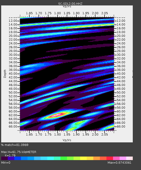
| Estimated Moho Depth: |
61.75 km |
| Estimated Crust Vp/Vs: |
1.79 |
| Assumed Crust Vp: |
6.232 km/s |
| Estimated Crust Vs: |
3.481 km/s |
| Estimated Crust Poisson's Ratio: |
0.27 |
|
| Radial Match: |
81.0969 % |
| Radial Bump: |
400 |
| Transverse Match: |
65.02105 % |
| Transverse Bump: |
400 |
| SOD ConfigId: |
30536071 |
| Insert Time: |
2023-03-18 07:04:57.671 +0000 |
| GWidth: |
2.5 |
| Max Bumps: |
400 |
| Tol: |
0.001 |
|

Signal To Noise
| Channel | StoN | STA | LTA |
| SC:GDL2:00:HHZ:20230304T06:53:43.184979Z | 15.803807 | 1.3522995E-7 | 8.556796E-9 |
| SC:GDL2:00:HHN:20230304T06:53:43.184979Z | 3.2114694 | 2.4515815E-8 | 7.633831E-9 |
| SC:GDL2:00:HHE:20230304T06:53:43.184979Z | 2.9400122 | 1.9277719E-8 | 6.5570203E-9 |
| Arrivals |
| Ps | 8.0 SECOND |
| PpPs | 27 SECOND |
| PsPs/PpSs | 35 SECOND |


