You are here: Home > Network List > TX - Texas Seismological Network Stations List
> Station MB10 Stanton > Earthquake Result Viewer
MB10 Stanton - Earthquake Result Viewer
| Earthquake location: |
Kermadec Islands, New Zealand |
| Earthquake latitude/longitude: |
-29.5/-178.8 |
| Earthquake time(UTC): |
2023/03/04 (063) 06:41:22 GMT |
| Earthquake Depth: |
206 km |
| Earthquake Magnitude: |
6.9 mww |
| Earthquake Catalog/Contributor: |
NEIC PDE/us |
|
| Network: |
TX Texas Seismological Network |
| Station: |
MB10 Stanton |
| Lat/Lon: |
32.27 N/101.79 W |
| Elevation: |
813 m |
|
| Distance: |
95.4 deg |
| Az: |
56.009 deg |
| Baz: |
238.582 deg |
| Ray Param: |
0.040639862 |
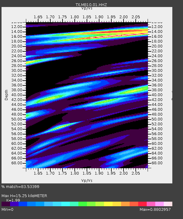
| Estimated Moho Depth: |
15.25 km |
| Estimated Crust Vp/Vs: |
1.99 |
| Assumed Crust Vp: |
6.426 km/s |
| Estimated Crust Vs: |
3.229 km/s |
| Estimated Crust Poisson's Ratio: |
0.33 |
|
| Radial Match: |
83.53399 % |
| Radial Bump: |
400 |
| Transverse Match: |
55.503807 % |
| Transverse Bump: |
386 |
| SOD ConfigId: |
30536071 |
| Insert Time: |
2023-03-18 07:06:15.920 +0000 |
| GWidth: |
2.5 |
| Max Bumps: |
400 |
| Tol: |
0.001 |
|

Signal To Noise
| Channel | StoN | STA | LTA |
| TX:MB10:01:HHZ:20230304T06:53:51.720013Z | 15.034648 | 2.4086144E-6 | 1.6020424E-7 |
| TX:MB10:01:HHN:20230304T06:53:51.720013Z | 4.0152583 | 9.523E-7 | 2.371703E-7 |
| TX:MB10:01:HHE:20230304T06:53:51.720013Z | 1.672219 | 6.917427E-7 | 4.1366752E-7 |
| Arrivals |
| Ps | 2.4 SECOND |
| PpPs | 7.0 SECOND |
| PsPs/PpSs | 9.4 SECOND |


