You are here: Home > Network List > G - GEOSCOPE Stations List
> Station ATD Arta Cave - Arta, Republic of Djibouti > Earthquake Result Viewer
ATD Arta Cave - Arta, Republic of Djibouti - Earthquake Result Viewer
| Earthquake location: |
Minahassa Peninsula, Sulawesi |
| Earthquake latitude/longitude: |
-0.2/119.8 |
| Earthquake time(UTC): |
2018/09/28 (271) 10:02:43 GMT |
| Earthquake Depth: |
10 km |
| Earthquake Magnitude: |
7.5 Mww |
| Earthquake Catalog/Contributor: |
NEIC PDE/us |
|
| Network: |
G GEOSCOPE |
| Station: |
ATD Arta Cave - Arta, Republic of Djibouti |
| Lat/Lon: |
11.53 N/42.85 E |
| Elevation: |
610 m |
|
| Distance: |
77.3 deg |
| Az: |
281.788 deg |
| Baz: |
92.804 deg |
| Ray Param: |
0.050420824 |
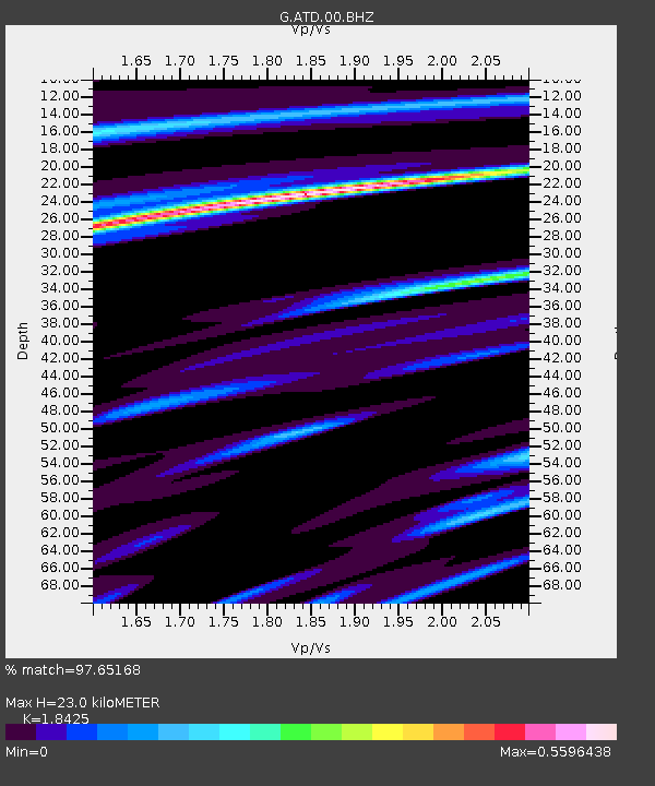
| Estimated Moho Depth: |
23.0 km |
| Estimated Crust Vp/Vs: |
1.84 |
| Assumed Crust Vp: |
6.375 km/s |
| Estimated Crust Vs: |
3.46 km/s |
| Estimated Crust Poisson's Ratio: |
0.29 |
|
| Radial Match: |
97.65168 % |
| Radial Bump: |
330 |
| Transverse Match: |
86.76383 % |
| Transverse Bump: |
400 |
| SOD ConfigId: |
3045211 |
| Insert Time: |
2018-10-12 10:08:22.762 +0000 |
| GWidth: |
2.5 |
| Max Bumps: |
400 |
| Tol: |
0.001 |
|
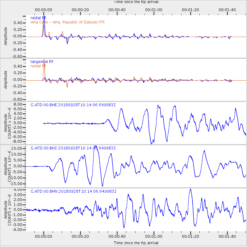
Signal To Noise
| Channel | StoN | STA | LTA |
| G:ATD:00:BHZ:20180928T10:14:06.649983Z | 16.521505 | 1.511365E-6 | 9.1478654E-8 |
| G:ATD:00:BHN:20180928T10:14:06.649983Z | 1.3499932 | 1.247174E-7 | 9.238372E-8 |
| G:ATD:00:BHE:20180928T10:14:06.649983Z | 5.879307 | 5.732141E-7 | 9.749689E-8 |
| Arrivals |
| Ps | 3.1 SECOND |
| PpPs | 10.0 SECOND |
| PsPs/PpSs | 13 SECOND |


