You are here: Home > Network List > US - United States National Seismic Network Stations List
> Station HAWA Hanford, Washington, USA > Earthquake Result Viewer
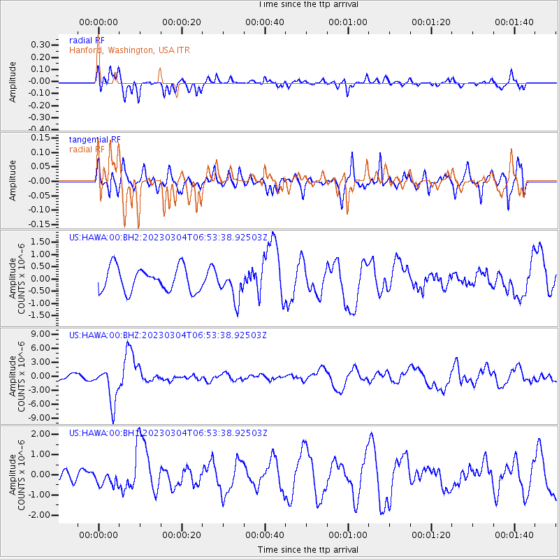
HAWA Hanford, Washington, USA - Earthquake Result Viewer
*The percent match for this event was below the threshold and hence no stack was calculated.
| Earthquake location: |
Kermadec Islands, New Zealand |
| Earthquake latitude/longitude: |
-29.5/-178.8 |
| Earthquake time(UTC): |
2023/03/04 (063) 06:41:22 GMT |
| Earthquake Depth: |
206 km |
| Earthquake Magnitude: |
6.9 mww |
| Earthquake Catalog/Contributor: |
NEIC PDE/us |
|
| Network: |
US United States National Seismic Network |
| Station: |
HAWA Hanford, Washington, USA |
| Lat/Lon: |
46.39 N/119.53 W |
| Elevation: |
364 m |
|
| Distance: |
92.6 deg |
| Az: |
36.545 deg |
| Baz: |
228.606 deg |
| Ray Param: |
$rayparam |
*The percent match for this event was below the threshold and hence was not used in the summary stack. |
|
| Radial Match: |
65.844696 % |
| Radial Bump: |
392 |
| Transverse Match: |
53.89347 % |
| Transverse Bump: |
379 |
| SOD ConfigId: |
30536071 |
| Insert Time: |
2023-03-18 07:09:06.867 +0000 |
| GWidth: |
2.5 |
| Max Bumps: |
400 |
| Tol: |
0.001 |
|
Signal To Noise
| Channel | StoN | STA | LTA |
| US:HAWA:00:BHZ:20230304T06:53:38.92503Z | 7.5985637 | 4.0450877E-6 | 5.32349E-7 |
| US:HAWA:00:BH1:20230304T06:53:38.92503Z | 1.772543 | 3.798917E-7 | 2.1432017E-7 |
| US:HAWA:00:BH2:20230304T06:53:38.92503Z | 1.2797183 | 6.2721193E-7 | 4.901172E-7 |
| Arrivals |
| Ps | |
| PpPs | |
| PsPs/PpSs | |


