You are here: Home > Network List > G - GEOSCOPE Stations List
> Station DZM Dzumac, New Caledonia > Earthquake Result Viewer
DZM Dzumac, New Caledonia - Earthquake Result Viewer
| Earthquake location: |
Minahassa Peninsula, Sulawesi |
| Earthquake latitude/longitude: |
-0.2/119.8 |
| Earthquake time(UTC): |
2018/09/28 (271) 10:02:43 GMT |
| Earthquake Depth: |
10 km |
| Earthquake Magnitude: |
7.5 Mww |
| Earthquake Catalog/Contributor: |
NEIC PDE/us |
|
| Network: |
G GEOSCOPE |
| Station: |
DZM Dzumac, New Caledonia |
| Lat/Lon: |
22.07 S/166.44 E |
| Elevation: |
878 m |
|
| Distance: |
50.3 deg |
| Az: |
118.872 deg |
| Baz: |
289.255 deg |
| Ray Param: |
0.06813393 |
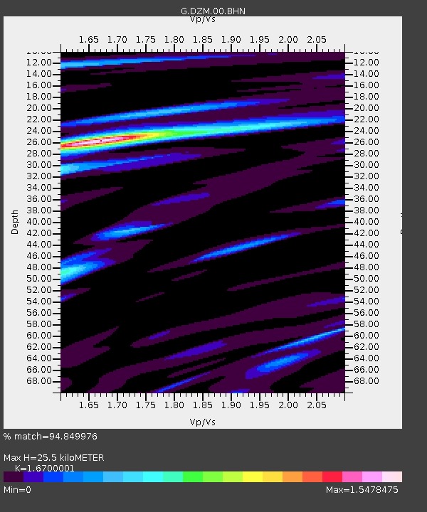
| Estimated Moho Depth: |
25.5 km |
| Estimated Crust Vp/Vs: |
1.67 |
| Assumed Crust Vp: |
5.14 km/s |
| Estimated Crust Vs: |
3.078 km/s |
| Estimated Crust Poisson's Ratio: |
0.22 |
|
| Radial Match: |
94.849976 % |
| Radial Bump: |
400 |
| Transverse Match: |
92.905914 % |
| Transverse Bump: |
400 |
| SOD ConfigId: |
3045211 |
| Insert Time: |
2018-10-12 10:08:32.164 +0000 |
| GWidth: |
2.5 |
| Max Bumps: |
400 |
| Tol: |
0.001 |
|
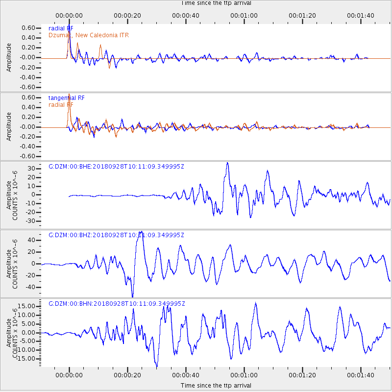
Signal To Noise
| Channel | StoN | STA | LTA |
| G:DZM:00:BHZ:20180928T10:11:09.349995Z | 2.9998353 | 2.821652E-6 | 9.406024E-7 |
| G:DZM:00:BHN:20180928T10:11:09.349995Z | 1.4367771 | 8.655072E-7 | 6.0239495E-7 |
| G:DZM:00:BHE:20180928T10:11:09.349995Z | 2.9925172 | 1.3692983E-6 | 4.5757406E-7 |
| Arrivals |
| Ps | 3.5 SECOND |
| PpPs | 13 SECOND |
| PsPs/PpSs | 16 SECOND |


