You are here: Home > Network List > G - GEOSCOPE Stations List
> Station RER Riviere de l'Est, La Reunion (Indian Ocean) > Earthquake Result Viewer
RER Riviere de l'Est, La Reunion (Indian Ocean) - Earthquake Result Viewer
| Earthquake location: |
Minahassa Peninsula, Sulawesi |
| Earthquake latitude/longitude: |
-0.2/119.8 |
| Earthquake time(UTC): |
2018/09/28 (271) 10:02:43 GMT |
| Earthquake Depth: |
10 km |
| Earthquake Magnitude: |
7.5 Mww |
| Earthquake Catalog/Contributor: |
NEIC PDE/us |
|
| Network: |
G GEOSCOPE |
| Station: |
RER Riviere de l'Est, La Reunion (Indian Ocean) |
| Lat/Lon: |
21.16 S/55.75 E |
| Elevation: |
834 m |
|
| Distance: |
65.9 deg |
| Az: |
246.93 deg |
| Baz: |
80.291 deg |
| Ray Param: |
0.05799196 |
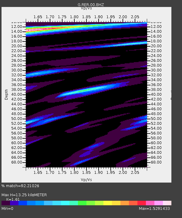
| Estimated Moho Depth: |
13.25 km |
| Estimated Crust Vp/Vs: |
1.61 |
| Assumed Crust Vp: |
4.73 km/s |
| Estimated Crust Vs: |
2.938 km/s |
| Estimated Crust Poisson's Ratio: |
0.19 |
|
| Radial Match: |
92.21026 % |
| Radial Bump: |
400 |
| Transverse Match: |
88.894844 % |
| Transverse Bump: |
400 |
| SOD ConfigId: |
3045211 |
| Insert Time: |
2018-10-12 10:08:38.942 +0000 |
| GWidth: |
2.5 |
| Max Bumps: |
400 |
| Tol: |
0.001 |
|
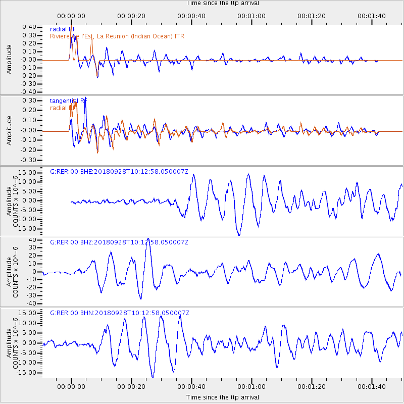
Signal To Noise
| Channel | StoN | STA | LTA |
| G:RER:00:BHZ:20180928T10:12:58.050007Z | 2.1468863 | 1.9683998E-6 | 9.1686263E-7 |
| G:RER:00:BHN:20180928T10:12:58.050007Z | 0.63889825 | 5.9694736E-7 | 9.343387E-7 |
| G:RER:00:BHE:20180928T10:12:58.050007Z | 1.3802701 | 8.7953185E-7 | 6.372172E-7 |
| Arrivals |
| Ps | 1.8 SECOND |
| PpPs | 7.1 SECOND |
| PsPs/PpSs | 8.9 SECOND |


