You are here: Home > Network List > IU - Global Seismograph Network (GSN - IRIS/USGS) Stations List
> Station MA2 Magadan, Russia > Earthquake Result Viewer
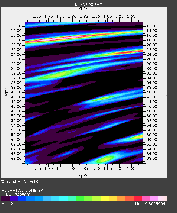
MA2 Magadan, Russia - Earthquake Result Viewer
| Earthquake location: |
Minahassa Peninsula, Sulawesi |
| Earthquake latitude/longitude: |
-0.2/119.8 |
| Earthquake time(UTC): |
2018/09/28 (271) 10:02:43 GMT |
| Earthquake Depth: |
10 km |
| Earthquake Magnitude: |
7.5 Mww |
| Earthquake Catalog/Contributor: |
NEIC PDE/us |
|
| Network: |
IU Global Seismograph Network (GSN - IRIS/USGS) |
| Station: |
MA2 Magadan, Russia |
| Lat/Lon: |
59.58 N/150.77 E |
| Elevation: |
339 m |
|
| Distance: |
64.3 deg |
| Az: |
16.878 deg |
| Baz: |
214.784 deg |
| Ray Param: |
0.059020076 |
| Estimated Moho Depth: |
17.0 km |
| Estimated Crust Vp/Vs: |
1.74 |
| Assumed Crust Vp: |
6.134 km/s |
| Estimated Crust Vs: |
3.52 km/s |
| Estimated Crust Poisson's Ratio: |
0.25 |
|
| Radial Match: |
97.99618 % |
| Radial Bump: |
254 |
| Transverse Match: |
94.7291 % |
| Transverse Bump: |
400 |
| SOD ConfigId: |
3045211 |
| Insert Time: |
2018-10-12 10:09:22.113 +0000 |
| GWidth: |
2.5 |
| Max Bumps: |
400 |
| Tol: |
0.001 |
|

Signal To Noise
| Channel | StoN | STA | LTA |
| IU:MA2:00:BHZ:20180928T10:12:47.719014Z | 15.022569 | 4.547087E-6 | 3.0268373E-7 |
| IU:MA2:00:BH1:20180928T10:12:47.719014Z | 5.2730584 | 1.7753878E-6 | 3.366903E-7 |
| IU:MA2:00:BH2:20180928T10:12:47.719014Z | 5.217772 | 1.0438348E-6 | 2.0005373E-7 |
| Arrivals |
| Ps | 2.1 SECOND |
| PpPs | 7.3 SECOND |
| PsPs/PpSs | 9.4 SECOND |


