You are here: Home > Network List > ND - New CaleDonia Broadband Seismic Network Stations List
> Station LIFNC Lifou, Loyalty Islands, New Caledonia > Earthquake Result Viewer
LIFNC Lifou, Loyalty Islands, New Caledonia - Earthquake Result Viewer
| Earthquake location: |
Minahassa Peninsula, Sulawesi |
| Earthquake latitude/longitude: |
-0.2/119.8 |
| Earthquake time(UTC): |
2018/09/28 (271) 10:02:43 GMT |
| Earthquake Depth: |
10 km |
| Earthquake Magnitude: |
7.5 Mww |
| Earthquake Catalog/Contributor: |
NEIC PDE/us |
|
| Network: |
ND New CaleDonia Broadband Seismic Network |
| Station: |
LIFNC Lifou, Loyalty Islands, New Caledonia |
| Lat/Lon: |
20.78 S/167.24 E |
| Elevation: |
33 m |
|
| Distance: |
50.6 deg |
| Az: |
116.982 deg |
| Baz: |
287.763 deg |
| Ray Param: |
0.06793509 |
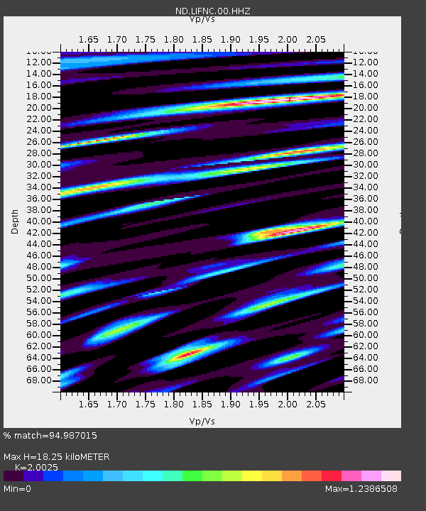
| Estimated Moho Depth: |
18.25 km |
| Estimated Crust Vp/Vs: |
2.00 |
| Assumed Crust Vp: |
4.662 km/s |
| Estimated Crust Vs: |
2.328 km/s |
| Estimated Crust Poisson's Ratio: |
0.33 |
|
| Radial Match: |
94.987015 % |
| Radial Bump: |
329 |
| Transverse Match: |
87.0211 % |
| Transverse Bump: |
400 |
| SOD ConfigId: |
3045211 |
| Insert Time: |
2018-10-12 10:09:43.243 +0000 |
| GWidth: |
2.5 |
| Max Bumps: |
400 |
| Tol: |
0.001 |
|

Signal To Noise
| Channel | StoN | STA | LTA |
| ND:LIFNC:00:HHZ:20180928T10:11:11.539998Z | 4.1913743 | 1.599867E-8 | 3.817047E-9 |
| ND:LIFNC:00:HHN:20180928T10:11:11.539998Z | 1.6382275 | 7.810338E-9 | 4.7675544E-9 |
| ND:LIFNC:00:HHE:20180928T10:11:11.539998Z | 0.98191655 | 4.7033906E-9 | 4.7900106E-9 |
| Arrivals |
| Ps | 4.0 SECOND |
| PpPs | 11 SECOND |
| PsPs/PpSs | 15 SECOND |


