You are here: Home > Network List > NO - Norwegian Seismic Array Network Stations List
> Station SPB3 > Earthquake Result Viewer
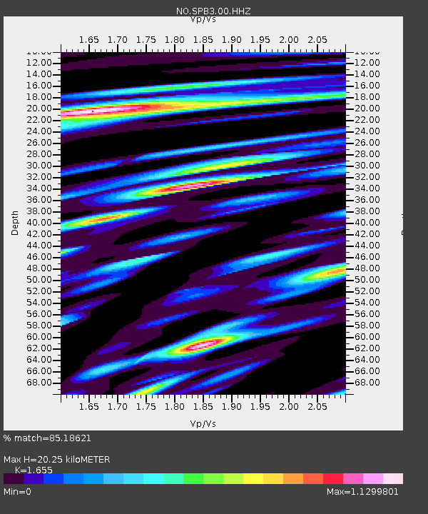
SPB3 - Earthquake Result Viewer
| Earthquake location: |
Minahassa Peninsula, Sulawesi |
| Earthquake latitude/longitude: |
-0.2/119.8 |
| Earthquake time(UTC): |
2018/09/28 (271) 10:02:43 GMT |
| Earthquake Depth: |
10 km |
| Earthquake Magnitude: |
7.5 Mww |
| Earthquake Catalog/Contributor: |
NEIC PDE/us |
|
| Network: |
NO Norwegian Seismic Array Network |
| Station: |
SPB3 |
| Lat/Lon: |
78.17 N/16.36 E |
| Elevation: |
234 m |
|
| Distance: |
92.9 deg |
| Az: |
348.414 deg |
| Baz: |
76.834 deg |
| Ray Param: |
0.041361257 |
| Estimated Moho Depth: |
20.25 km |
| Estimated Crust Vp/Vs: |
1.65 |
| Assumed Crust Vp: |
6.545 km/s |
| Estimated Crust Vs: |
3.955 km/s |
| Estimated Crust Poisson's Ratio: |
0.21 |
|
| Radial Match: |
85.18621 % |
| Radial Bump: |
400 |
| Transverse Match: |
82.725334 % |
| Transverse Bump: |
400 |
| SOD ConfigId: |
3045211 |
| Insert Time: |
2018-10-12 10:09:57.364 +0000 |
| GWidth: |
2.5 |
| Max Bumps: |
400 |
| Tol: |
0.001 |
|

Signal To Noise
| Channel | StoN | STA | LTA |
| NO:SPB3:00:HHZ:20180928T10:15:25.024983Z | 3.4014254 | 3.687479E-7 | 1.08409814E-7 |
| NO:SPB3:00:HHN:20180928T10:15:25.024983Z | 1.2856265 | 1.3585164E-7 | 1.056696E-7 |
| NO:SPB3:00:HHE:20180928T10:15:25.024983Z | 1.5385212 | 1.87541E-7 | 1.2189693E-7 |
| Arrivals |
| Ps | 2.1 SECOND |
| PpPs | 8.0 SECOND |
| PsPs/PpSs | 10 SECOND |


