You are here: Home > Network List > PF - Volcanologic Network of Piton de Fournaise-OVPF Stations List
> Station CIL Cilaos (Pompiers) > Earthquake Result Viewer
CIL Cilaos (Pompiers) - Earthquake Result Viewer
| Earthquake location: |
Minahassa Peninsula, Sulawesi |
| Earthquake latitude/longitude: |
-0.2/119.8 |
| Earthquake time(UTC): |
2018/09/28 (271) 10:02:43 GMT |
| Earthquake Depth: |
10 km |
| Earthquake Magnitude: |
7.5 Mww |
| Earthquake Catalog/Contributor: |
NEIC PDE/us |
|
| Network: |
PF Volcanologic Network of Piton de Fournaise-OVPF |
| Station: |
CIL Cilaos (Pompiers) |
| Lat/Lon: |
21.13 S/55.47 E |
| Elevation: |
1223 m |
|
| Distance: |
66.1 deg |
| Az: |
247.005 deg |
| Baz: |
80.421 deg |
| Ray Param: |
0.057828125 |
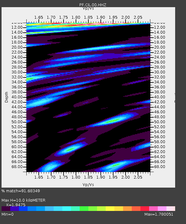
| Estimated Moho Depth: |
10.0 km |
| Estimated Crust Vp/Vs: |
1.95 |
| Assumed Crust Vp: |
4.73 km/s |
| Estimated Crust Vs: |
2.429 km/s |
| Estimated Crust Poisson's Ratio: |
0.32 |
|
| Radial Match: |
91.68349 % |
| Radial Bump: |
400 |
| Transverse Match: |
80.03095 % |
| Transverse Bump: |
400 |
| SOD ConfigId: |
3045211 |
| Insert Time: |
2018-10-12 10:10:04.474 +0000 |
| GWidth: |
2.5 |
| Max Bumps: |
400 |
| Tol: |
0.001 |
|
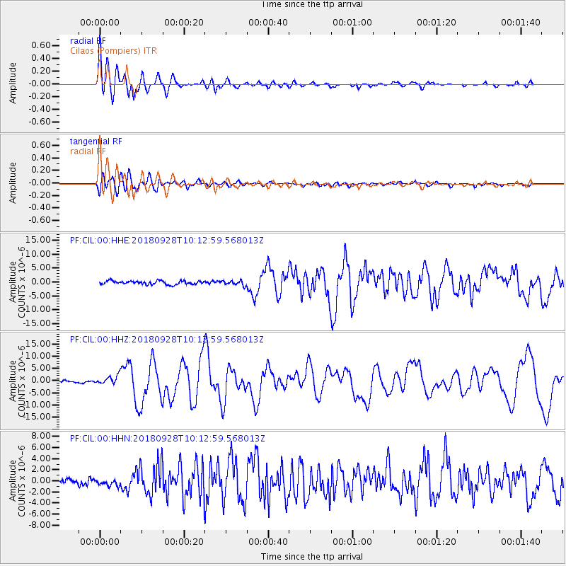
Signal To Noise
| Channel | StoN | STA | LTA |
| PF:CIL:00:HHZ:20180928T10:12:59.568013Z | 4.511994 | 1.8602266E-6 | 4.122848E-7 |
| PF:CIL:00:HHN:20180928T10:12:59.568013Z | 1.0585582 | 6.231516E-7 | 5.886796E-7 |
| PF:CIL:00:HHE:20180928T10:12:59.568013Z | 1.3590714 | 8.4655653E-7 | 6.2289337E-7 |
| Arrivals |
| Ps | 2.0 SECOND |
| PpPs | 6.1 SECOND |
| PsPs/PpSs | 8.2 SECOND |


