You are here: Home > Network List > PF - Volcanologic Network of Piton de Fournaise-OVPF Stations List
> Station GBS Grandes pentes coulee 1943 bas > Earthquake Result Viewer
GBS Grandes pentes coulee 1943 bas - Earthquake Result Viewer
| Earthquake location: |
Minahassa Peninsula, Sulawesi |
| Earthquake latitude/longitude: |
-0.2/119.8 |
| Earthquake time(UTC): |
2018/09/28 (271) 10:02:43 GMT |
| Earthquake Depth: |
10 km |
| Earthquake Magnitude: |
7.5 Mww |
| Earthquake Catalog/Contributor: |
NEIC PDE/us |
|
| Network: |
PF Volcanologic Network of Piton de Fournaise-OVPF |
| Station: |
GBS Grandes pentes coulee 1943 bas |
| Lat/Lon: |
21.27 S/55.78 E |
| Elevation: |
471 m |
|
| Distance: |
65.9 deg |
| Az: |
246.801 deg |
| Baz: |
80.226 deg |
| Ray Param: |
0.05799939 |
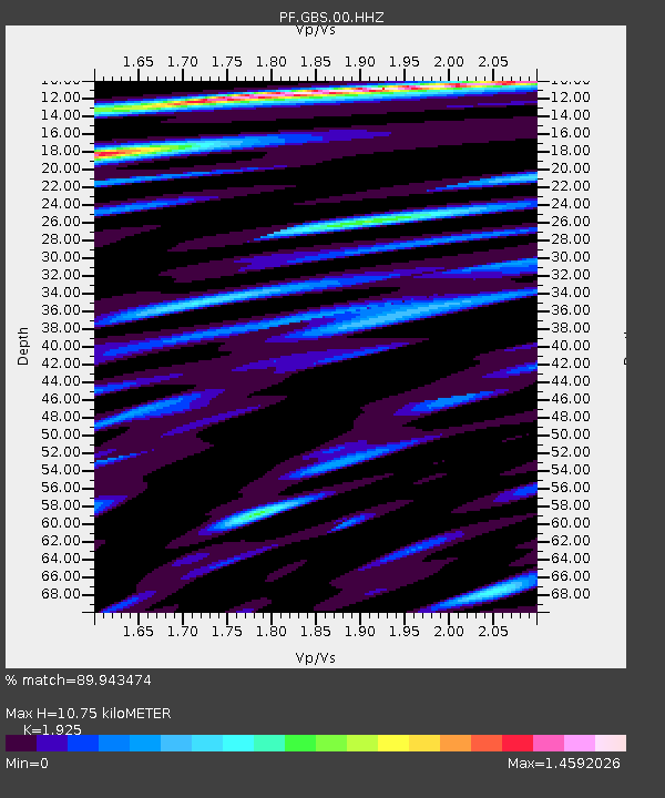
| Estimated Moho Depth: |
10.75 km |
| Estimated Crust Vp/Vs: |
1.92 |
| Assumed Crust Vp: |
4.73 km/s |
| Estimated Crust Vs: |
2.457 km/s |
| Estimated Crust Poisson's Ratio: |
0.32 |
|
| Radial Match: |
89.943474 % |
| Radial Bump: |
400 |
| Transverse Match: |
85.32343 % |
| Transverse Bump: |
400 |
| SOD ConfigId: |
3045211 |
| Insert Time: |
2018-10-12 10:10:11.423 +0000 |
| GWidth: |
2.5 |
| Max Bumps: |
400 |
| Tol: |
0.001 |
|
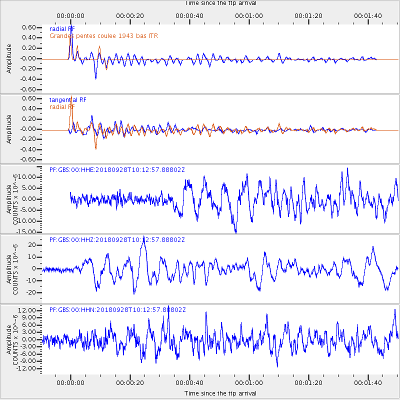
Signal To Noise
| Channel | StoN | STA | LTA |
| PF:GBS:00:HHZ:20180928T10:12:57.88802Z | 2.2267504 | 2.5911497E-6 | 1.1636463E-6 |
| PF:GBS:00:HHN:20180928T10:12:57.88802Z | 1.1001117 | 1.7619514E-6 | 1.6016112E-6 |
| PF:GBS:00:HHE:20180928T10:12:57.88802Z | 1.1995394 | 1.7977899E-6 | 1.4987335E-6 |
| Arrivals |
| Ps | 2.1 SECOND |
| PpPs | 6.5 SECOND |
| PsPs/PpSs | 8.7 SECOND |


