You are here: Home > Network List > PF - Volcanologic Network of Piton de Fournaise-OVPF Stations List
> Station HDL Station Sismologique de Hubert Delisle > Earthquake Result Viewer
HDL Station Sismologique de Hubert Delisle - Earthquake Result Viewer
| Earthquake location: |
Minahassa Peninsula, Sulawesi |
| Earthquake latitude/longitude: |
-0.2/119.8 |
| Earthquake time(UTC): |
2018/09/28 (271) 10:02:43 GMT |
| Earthquake Depth: |
10 km |
| Earthquake Magnitude: |
7.5 Mww |
| Earthquake Catalog/Contributor: |
NEIC PDE/us |
|
| Network: |
PF Volcanologic Network of Piton de Fournaise-OVPF |
| Station: |
HDL Station Sismologique de Hubert Delisle |
| Lat/Lon: |
21.25 S/55.79 E |
| Elevation: |
242 m |
|
| Distance: |
65.8 deg |
| Az: |
246.824 deg |
| Baz: |
80.232 deg |
| Ray Param: |
0.05800875 |
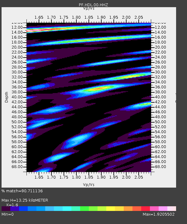
| Estimated Moho Depth: |
13.25 km |
| Estimated Crust Vp/Vs: |
1.60 |
| Assumed Crust Vp: |
4.73 km/s |
| Estimated Crust Vs: |
2.956 km/s |
| Estimated Crust Poisson's Ratio: |
0.18 |
|
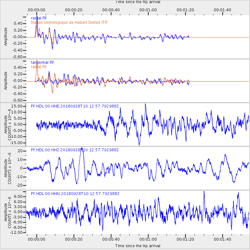
| Radial Match: |
90.711136 % |
| Radial Bump: |
400 |
| Transverse Match: |
81.633064 % |
| Transverse Bump: |
400 |
| SOD ConfigId: |
3045211 |
| Insert Time: |
2018-10-12 10:10:16.472 +0000 |
| GWidth: |
2.5 |
| Max Bumps: |
400 |
| Tol: |
0.001 |
|
Signal To Noise
| Channel | StoN | STA | LTA |
| PF:HDL:00:HHZ:20180928T10:12:57.792988Z | 3.0331511 | 2.7301503E-6 | 9.0010366E-7 |
| PF:HDL:00:HHN:20180928T10:12:57.792988Z | 0.88236165 | 1.5148496E-6 | 1.7168126E-6 |
| PF:HDL:00:HHE:20180928T10:12:57.792988Z | 1.4000432 | 2.3260009E-6 | 1.661378E-6 |
| Arrivals |
| Ps | 1.7 SECOND |
| PpPs | 7.1 SECOND |
| PsPs/PpSs | 8.8 SECOND |


