You are here: Home > Network List > PF - Volcanologic Network of Piton de Fournaise-OVPF Stations List
> Station PRA Puys Ramond > Earthquake Result Viewer
PRA Puys Ramond - Earthquake Result Viewer
| Earthquake location: |
Minahassa Peninsula, Sulawesi |
| Earthquake latitude/longitude: |
-0.2/119.8 |
| Earthquake time(UTC): |
2018/09/28 (271) 10:02:43 GMT |
| Earthquake Depth: |
10 km |
| Earthquake Magnitude: |
7.5 Mww |
| Earthquake Catalog/Contributor: |
NEIC PDE/us |
|
| Network: |
PF Volcanologic Network of Piton de Fournaise-OVPF |
| Station: |
PRA Puys Ramond |
| Lat/Lon: |
21.29 S/55.71 E |
| Elevation: |
2009 m |
|
| Distance: |
65.9 deg |
| Az: |
246.794 deg |
| Baz: |
80.249 deg |
| Ray Param: |
0.0579543 |
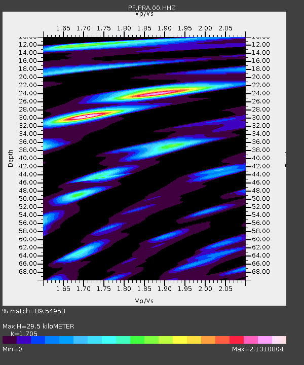
| Estimated Moho Depth: |
29.5 km |
| Estimated Crust Vp/Vs: |
1.71 |
| Assumed Crust Vp: |
4.73 km/s |
| Estimated Crust Vs: |
2.774 km/s |
| Estimated Crust Poisson's Ratio: |
0.24 |
|
| Radial Match: |
89.54953 % |
| Radial Bump: |
400 |
| Transverse Match: |
81.32494 % |
| Transverse Bump: |
400 |
| SOD ConfigId: |
3045211 |
| Insert Time: |
2018-10-12 10:10:23.905 +0000 |
| GWidth: |
2.5 |
| Max Bumps: |
400 |
| Tol: |
0.001 |
|
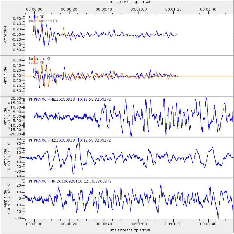
Signal To Noise
| Channel | StoN | STA | LTA |
| PF:PRA:00:HHZ:20180928T10:12:58.320027Z | 2.7509212 | 2.815198E-6 | 1.0233656E-6 |
| PF:PRA:00:HHN:20180928T10:12:58.320027Z | 0.9698594 | 2.430951E-6 | 2.5064985E-6 |
| PF:PRA:00:HHE:20180928T10:12:58.320027Z | 1.07375 | 2.120531E-6 | 1.9748832E-6 |
| Arrivals |
| Ps | 4.5 SECOND |
| PpPs | 16 SECOND |
| PsPs/PpSs | 21 SECOND |


