You are here: Home > Network List > IW - Intermountain West Stations List
> Station MOOW Moose Ponds, Wyoming, USA > Earthquake Result Viewer
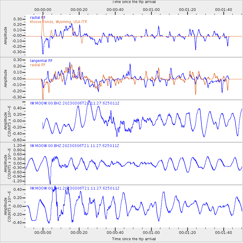
MOOW Moose Ponds, Wyoming, USA - Earthquake Result Viewer
*The percent match for this event was below the threshold and hence no stack was calculated.
| Earthquake location: |
Fiji Islands Region |
| Earthquake latitude/longitude: |
-20.8/-178.3 |
| Earthquake time(UTC): |
2023/03/06 (065) 20:59:59 GMT |
| Earthquake Depth: |
526 km |
| Earthquake Magnitude: |
5.8 mww |
| Earthquake Catalog/Contributor: |
NEIC PDE/us |
|
| Network: |
IW Intermountain West |
| Station: |
MOOW Moose Ponds, Wyoming, USA |
| Lat/Lon: |
43.75 N/110.74 W |
| Elevation: |
2128 m |
|
| Distance: |
89.1 deg |
| Az: |
42.058 deg |
| Baz: |
239.877 deg |
| Ray Param: |
$rayparam |
*The percent match for this event was below the threshold and hence was not used in the summary stack. |
|
| Radial Match: |
40.142048 % |
| Radial Bump: |
400 |
| Transverse Match: |
40.90469 % |
| Transverse Bump: |
400 |
| SOD ConfigId: |
30536071 |
| Insert Time: |
2023-03-20 21:16:12.357 +0000 |
| GWidth: |
2.5 |
| Max Bumps: |
400 |
| Tol: |
0.001 |
|
Signal To Noise
| Channel | StoN | STA | LTA |
| IW:MOOW:00:BHZ:20230306T21:11:27.625011Z | 2.48752 | 5.6560793E-7 | 2.2737825E-7 |
| IW:MOOW:00:BH1:20230306T21:11:27.625011Z | 1.5648324 | 2.4141073E-7 | 1.5427257E-7 |
| IW:MOOW:00:BH2:20230306T21:11:27.625011Z | 1.5476286 | 3.3172978E-7 | 2.1434715E-7 |
| Arrivals |
| Ps | |
| PpPs | |
| PsPs/PpSs | |


