You are here: Home > Network List > TA - USArray Transportable Network (new EarthScope stations) Stations List
> Station TOLK Toolik Lake Research Station, AK, USA > Earthquake Result Viewer
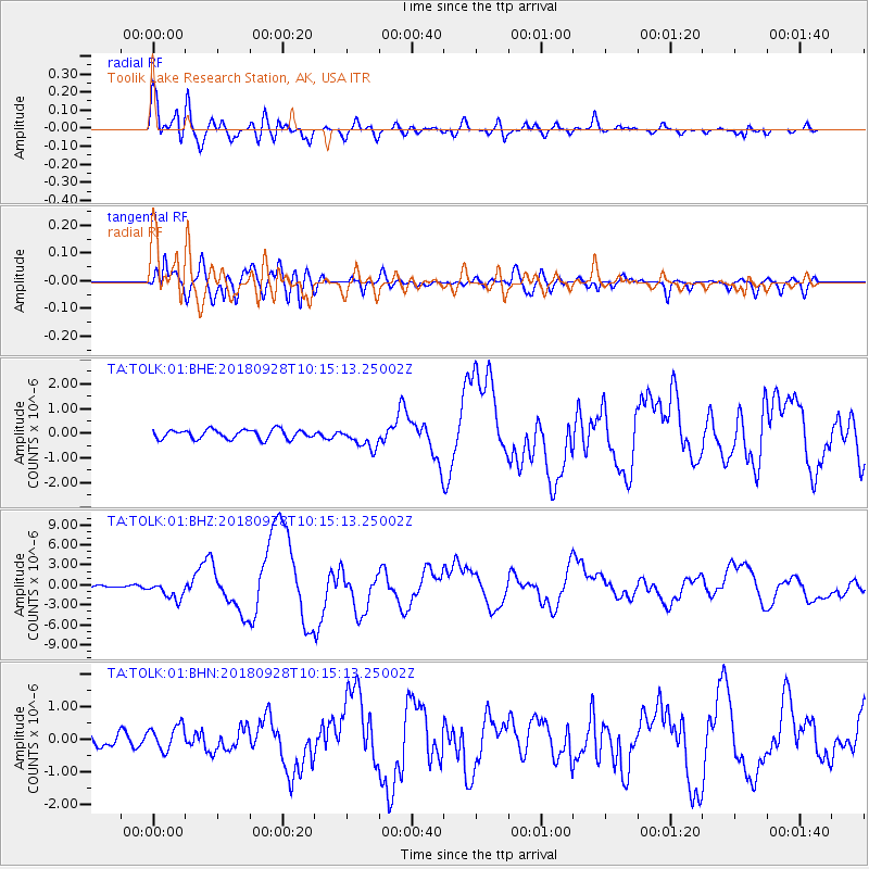
TOLK Toolik Lake Research Station, AK, USA - Earthquake Result Viewer

| Earthquake location: |
Minahassa Peninsula, Sulawesi |
| Earthquake latitude/longitude: |
-0.2/119.8 |
| Earthquake time(UTC): |
2018/09/28 (271) 10:02:43 GMT |
| Earthquake Depth: |
10 km |
| Earthquake Magnitude: |
7.5 Mww |
| Earthquake Catalog/Contributor: |
NEIC PDE/us |
|
| Network: |
TA USArray Transportable Network (new EarthScope stations) |
| Station: |
TOLK Toolik Lake Research Station, AK, USA |
| Lat/Lon: |
68.64 N/149.57 W |
| Elevation: |
760 m |
|
| Distance: |
90.4 deg |
| Az: |
21.489 deg |
| Baz: |
270.482 deg |
| Ray Param: |
0.041677523 |
| Estimated Moho Depth: |
11.5 km |
| Estimated Crust Vp/Vs: |
2.06 |
| Assumed Crust Vp: |
6.316 km/s |
| Estimated Crust Vs: |
3.062 km/s |
| Estimated Crust Poisson's Ratio: |
0.35 |
|
| Radial Match: |
89.79022 % |
| Radial Bump: |
400 |
| Transverse Match: |
83.25635 % |
| Transverse Bump: |
400 |
| SOD ConfigId: |
3045211 |
| Insert Time: |
2018-10-12 10:10:39.111 +0000 |
| GWidth: |
2.5 |
| Max Bumps: |
400 |
| Tol: |
0.001 |
|
Signal To Noise
| Channel | StoN | STA | LTA |
| TA:TOLK:01:BHZ:20180928T10:15:13.25002Z | 8.096245 | 1.411945E-6 | 1.7439505E-7 |
| TA:TOLK:01:BHN:20180928T10:15:13.25002Z | 1.1900887 | 3.7547366E-7 | 3.1550053E-7 |
| TA:TOLK:01:BHE:20180928T10:15:13.25002Z | 2.230774 | 4.217555E-7 | 1.8906239E-7 |
| Arrivals |
| Ps | 2.0 SECOND |
| PpPs | 5.5 SECOND |
| PsPs/PpSs | 7.4 SECOND |


