You are here: Home > Network List > US - United States National Seismic Network Stations List
> Station NEW Newport, Washington, USA > Earthquake Result Viewer
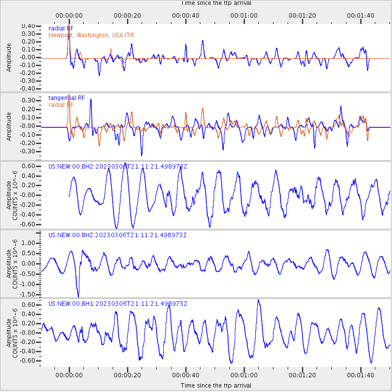
NEW Newport, Washington, USA - Earthquake Result Viewer
*The percent match for this event was below the threshold and hence no stack was calculated.
| Earthquake location: |
Fiji Islands Region |
| Earthquake latitude/longitude: |
-20.8/-178.3 |
| Earthquake time(UTC): |
2023/03/06 (065) 20:59:59 GMT |
| Earthquake Depth: |
526 km |
| Earthquake Magnitude: |
5.8 mww |
| Earthquake Catalog/Contributor: |
NEIC PDE/us |
|
| Network: |
US United States National Seismic Network |
| Station: |
NEW Newport, Washington, USA |
| Lat/Lon: |
48.26 N/117.12 W |
| Elevation: |
760 m |
|
| Distance: |
87.8 deg |
| Az: |
35.865 deg |
| Baz: |
235.13 deg |
| Ray Param: |
$rayparam |
*The percent match for this event was below the threshold and hence was not used in the summary stack. |
|
| Radial Match: |
45.879288 % |
| Radial Bump: |
400 |
| Transverse Match: |
66.79642 % |
| Transverse Bump: |
400 |
| SOD ConfigId: |
30536071 |
| Insert Time: |
2023-03-20 21:24:01.231 +0000 |
| GWidth: |
2.5 |
| Max Bumps: |
400 |
| Tol: |
0.001 |
|
Signal To Noise
| Channel | StoN | STA | LTA |
| US:NEW:00:BHZ:20230306T21:11:21.498973Z | 2.7565134 | 6.6760583E-7 | 2.4219213E-7 |
| US:NEW:00:BH1:20230306T21:11:21.498973Z | 0.4081185 | 1.0734542E-7 | 2.6302516E-7 |
| US:NEW:00:BH2:20230306T21:11:21.498973Z | 0.4006021 | 1.3746975E-7 | 3.4315784E-7 |
| Arrivals |
| Ps | |
| PpPs | |
| PsPs/PpSs | |


