You are here: Home > Network List > IU - Global Seismograph Network (GSN - IRIS/USGS) Stations List
> Station JOHN Johnston Island, USA > Earthquake Result Viewer
JOHN Johnston Island, USA - Earthquake Result Viewer
| Earthquake location: |
Sulawesi, Indonesia |
| Earthquake latitude/longitude: |
-1.1/120.0 |
| Earthquake time(UTC): |
2018/09/28 (271) 10:25:04 GMT |
| Earthquake Depth: |
10 km |
| Earthquake Magnitude: |
5.8 mb |
| Earthquake Catalog/Contributor: |
NEIC PDE/us |
|
| Network: |
IU Global Seismograph Network (GSN - IRIS/USGS) |
| Station: |
JOHN Johnston Island, USA |
| Lat/Lon: |
16.73 N/169.53 W |
| Elevation: |
2.0 m |
|
| Distance: |
71.7 deg |
| Az: |
72.087 deg |
| Baz: |
263.157 deg |
| Ray Param: |
0.05416836 |
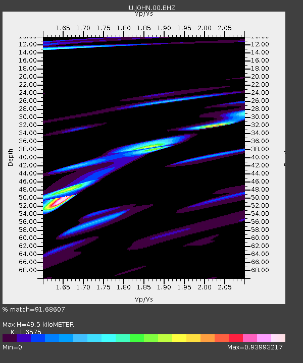
| Estimated Moho Depth: |
49.5 km |
| Estimated Crust Vp/Vs: |
1.66 |
| Assumed Crust Vp: |
4.24 km/s |
| Estimated Crust Vs: |
2.558 km/s |
| Estimated Crust Poisson's Ratio: |
0.21 |
|
| Radial Match: |
91.68607 % |
| Radial Bump: |
400 |
| Transverse Match: |
43.20657 % |
| Transverse Bump: |
400 |
| SOD ConfigId: |
3045211 |
| Insert Time: |
2018-10-12 10:26:15.887 +0000 |
| GWidth: |
2.5 |
| Max Bumps: |
400 |
| Tol: |
0.001 |
|
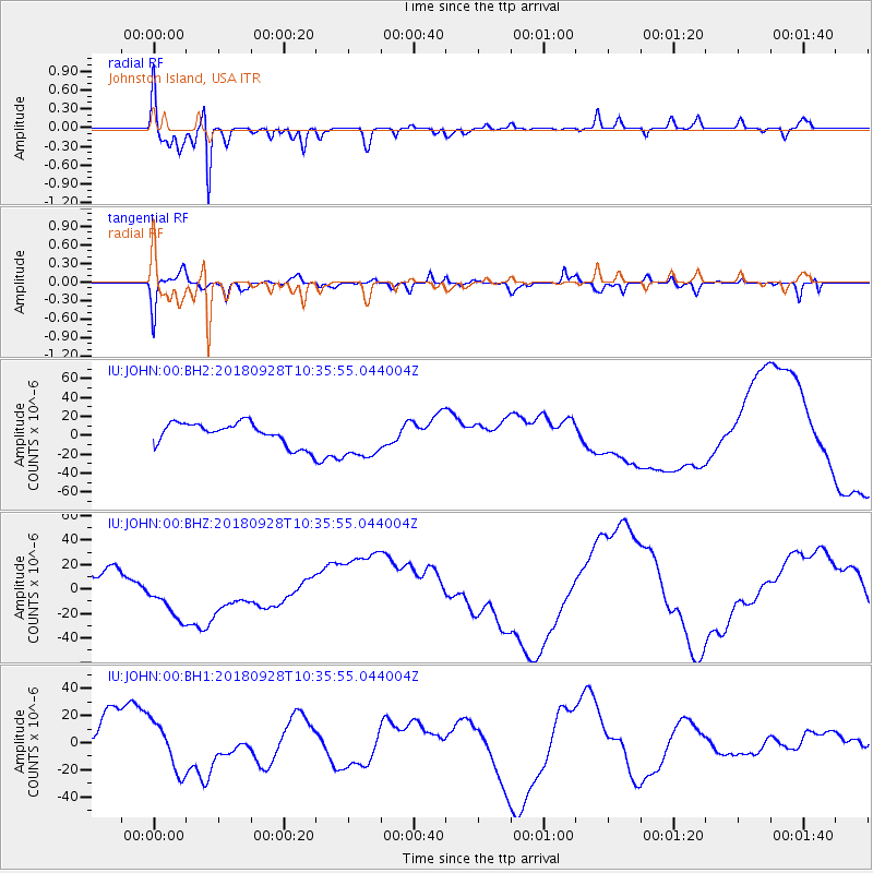
Signal To Noise
| Channel | StoN | STA | LTA |
| IU:JOHN:00:BHZ:20180928T10:35:55.044004Z | 2.1935122 | 2.1292688E-5 | 9.7071215E-6 |
| IU:JOHN:00:BH1:20180928T10:35:55.044004Z | 1.0108818 | 1.7962664E-5 | 1.7769302E-5 |
| IU:JOHN:00:BH2:20180928T10:35:55.044004Z | 1.9554613 | 2.3159948E-5 | 1.18437265E-5 |
| Arrivals |
| Ps | 7.8 SECOND |
| PpPs | 31 SECOND |
| PsPs/PpSs | 38 SECOND |


