You are here: Home > Network List > G - GEOSCOPE Stations List
> Station CRZF Port Alfred, Crozet, South Indian Ocean > Earthquake Result Viewer
CRZF Port Alfred, Crozet, South Indian Ocean - Earthquake Result Viewer
| Earthquake location: |
Minahassa Peninsula, Sulawesi |
| Earthquake latitude/longitude: |
-0.8/119.9 |
| Earthquake time(UTC): |
2018/09/28 (271) 10:50:25 GMT |
| Earthquake Depth: |
10 km |
| Earthquake Magnitude: |
5.7 mb |
| Earthquake Catalog/Contributor: |
NEIC PDE/us |
|
| Network: |
G GEOSCOPE |
| Station: |
CRZF Port Alfred, Crozet, South Indian Ocean |
| Lat/Lon: |
46.43 S/51.86 E |
| Elevation: |
140 m |
|
| Distance: |
74.5 deg |
| Az: |
221.757 deg |
| Baz: |
74.316 deg |
| Ray Param: |
0.05230453 |
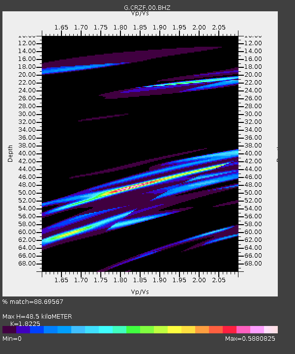
| Estimated Moho Depth: |
48.5 km |
| Estimated Crust Vp/Vs: |
1.82 |
| Assumed Crust Vp: |
4.802 km/s |
| Estimated Crust Vs: |
2.635 km/s |
| Estimated Crust Poisson's Ratio: |
0.28 |
|
| Radial Match: |
88.69567 % |
| Radial Bump: |
400 |
| Transverse Match: |
69.96714 % |
| Transverse Bump: |
400 |
| SOD ConfigId: |
3045211 |
| Insert Time: |
2018-10-12 11:04:49.433 +0000 |
| GWidth: |
2.5 |
| Max Bumps: |
400 |
| Tol: |
0.001 |
|
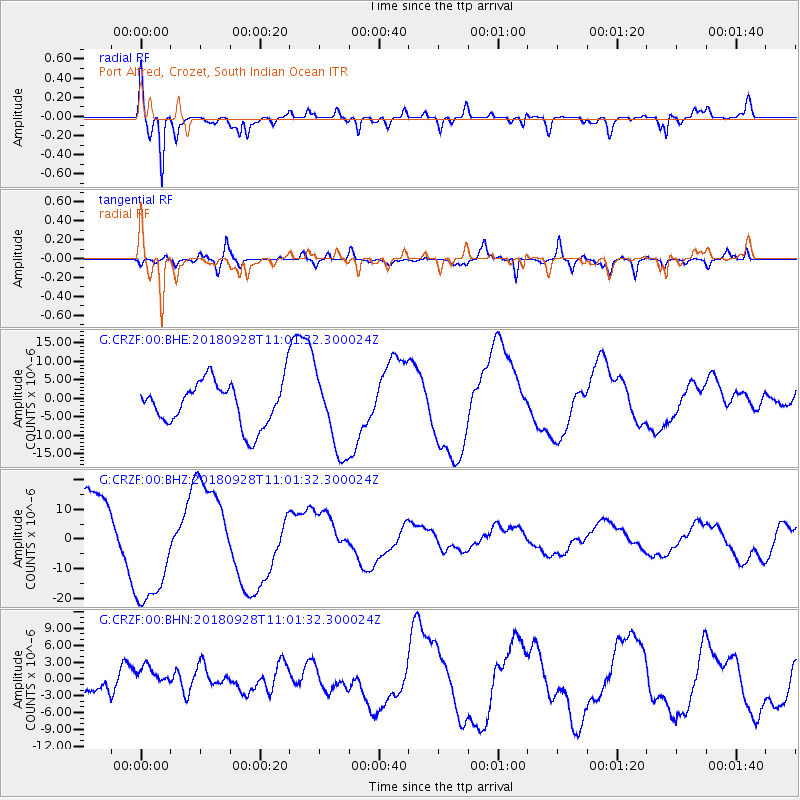
Signal To Noise
| Channel | StoN | STA | LTA |
| G:CRZF:00:BHZ:20180928T11:01:32.300024Z | 2.3163002 | 1.9803872E-5 | 8.549787E-6 |
| G:CRZF:00:BHN:20180928T11:01:32.300024Z | 0.64968354 | 2.0707591E-6 | 3.187335E-6 |
| G:CRZF:00:BHE:20180928T11:01:32.300024Z | 1.8076336 | 1.0817301E-5 | 5.984233E-6 |
| Arrivals |
| Ps | 8.5 SECOND |
| PpPs | 28 SECOND |
| PsPs/PpSs | 36 SECOND |


