You are here: Home > Network List > PF - Volcanologic Network of Piton de Fournaise-OVPF Stations List
> Station CIL Cilaos (Pompiers) > Earthquake Result Viewer
CIL Cilaos (Pompiers) - Earthquake Result Viewer
| Earthquake location: |
Minahassa Peninsula, Sulawesi |
| Earthquake latitude/longitude: |
-0.8/119.9 |
| Earthquake time(UTC): |
2018/09/28 (271) 10:50:25 GMT |
| Earthquake Depth: |
10 km |
| Earthquake Magnitude: |
5.7 mb |
| Earthquake Catalog/Contributor: |
NEIC PDE/us |
|
| Network: |
PF Volcanologic Network of Piton de Fournaise-OVPF |
| Station: |
CIL Cilaos (Pompiers) |
| Lat/Lon: |
21.13 S/55.47 E |
| Elevation: |
1223 m |
|
| Distance: |
66.0 deg |
| Az: |
247.257 deg |
| Baz: |
81.043 deg |
| Ray Param: |
0.05790897 |
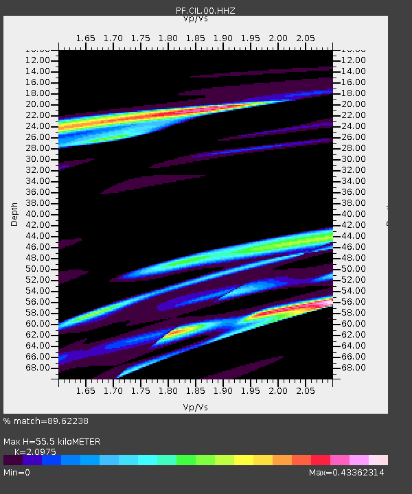
| Estimated Moho Depth: |
55.5 km |
| Estimated Crust Vp/Vs: |
2.10 |
| Assumed Crust Vp: |
4.73 km/s |
| Estimated Crust Vs: |
2.255 km/s |
| Estimated Crust Poisson's Ratio: |
0.35 |
|
| Radial Match: |
89.62238 % |
| Radial Bump: |
380 |
| Transverse Match: |
84.37454 % |
| Transverse Bump: |
400 |
| SOD ConfigId: |
3045211 |
| Insert Time: |
2018-10-12 11:05:55.662 +0000 |
| GWidth: |
2.5 |
| Max Bumps: |
400 |
| Tol: |
0.001 |
|
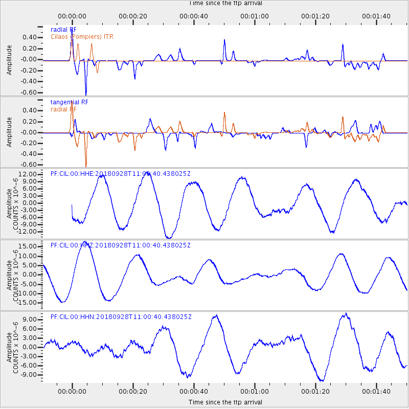
Signal To Noise
| Channel | StoN | STA | LTA |
| PF:CIL:00:HHZ:20180928T11:00:40.438025Z | 2.1605809 | 1.1824923E-5 | 5.4730294E-6 |
| PF:CIL:00:HHN:20180928T11:00:40.438025Z | 0.60579395 | 1.415562E-6 | 2.3367054E-6 |
| PF:CIL:00:HHE:20180928T11:00:40.438025Z | 1.4865085 | 1.1604855E-5 | 7.806787E-6 |
| Arrivals |
| Ps | 13 SECOND |
| PpPs | 36 SECOND |
| PsPs/PpSs | 49 SECOND |


