You are here: Home > Network List > AU - Australian Seismological Centre Stations List
> Station PSAA3 Pilbara Seismic Array Element A3 > Earthquake Result Viewer
PSAA3 Pilbara Seismic Array Element A3 - Earthquake Result Viewer
| Earthquake location: |
Fiji Islands Region |
| Earthquake latitude/longitude: |
-18.4/-178.1 |
| Earthquake time(UTC): |
2018/09/30 (273) 10:52:23 GMT |
| Earthquake Depth: |
551 km |
| Earthquake Magnitude: |
6.6 mww |
| Earthquake Catalog/Contributor: |
NEIC PDE/us |
|
| Network: |
AU Australian Seismological Centre |
| Station: |
PSAA3 Pilbara Seismic Array Element A3 |
| Lat/Lon: |
21.58 S/119.85 E |
| Elevation: |
315 m |
|
| Distance: |
58.1 deg |
| Az: |
255.635 deg |
| Baz: |
98.732 deg |
| Ray Param: |
0.06084465 |
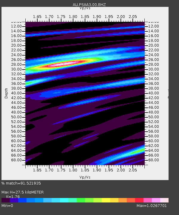
| Estimated Moho Depth: |
27.5 km |
| Estimated Crust Vp/Vs: |
1.76 |
| Assumed Crust Vp: |
6.464 km/s |
| Estimated Crust Vs: |
3.672 km/s |
| Estimated Crust Poisson's Ratio: |
0.26 |
|
| Radial Match: |
91.521935 % |
| Radial Bump: |
305 |
| Transverse Match: |
69.180145 % |
| Transverse Bump: |
400 |
| SOD ConfigId: |
3045211 |
| Insert Time: |
2018-10-14 11:07:08.410 +0000 |
| GWidth: |
2.5 |
| Max Bumps: |
400 |
| Tol: |
0.001 |
|

Signal To Noise
| Channel | StoN | STA | LTA |
| AU:PSAA3:00:BHZ:20180930T11:00:53.169015Z | 32.376423 | 1.0293886E-5 | 3.179439E-7 |
| AU:PSAA3:00:BH1:20180930T11:00:53.169015Z | 4.2244854 | 1.2002353E-6 | 2.8411395E-7 |
| AU:PSAA3:00:BH2:20180930T11:00:53.169015Z | 15.550697 | 4.9367754E-6 | 3.1746328E-7 |
| Arrivals |
| Ps | 3.4 SECOND |
| PpPs | 11 SECOND |
| PsPs/PpSs | 15 SECOND |


