You are here: Home > Network List > TM - Thai Seismic Monitoring Network Stations List
> Station PANO PANO staion > Earthquake Result Viewer
PANO PANO staion - Earthquake Result Viewer
| Earthquake location: |
Kuril Islands |
| Earthquake latitude/longitude: |
50.1/157.4 |
| Earthquake time(UTC): |
2023/03/08 (067) 06:03:36 GMT |
| Earthquake Depth: |
36 km |
| Earthquake Magnitude: |
5.6 Mww |
| Earthquake Catalog/Contributor: |
NEIC PDE/us |
|
| Network: |
TM Thai Seismic Monitoring Network |
| Station: |
PANO PANO staion |
| Lat/Lon: |
17.15 N/104.61 E |
| Elevation: |
136 m |
|
| Distance: |
53.4 deg |
| Az: |
251.59 deg |
| Baz: |
39.692 deg |
| Ray Param: |
0.06605693 |
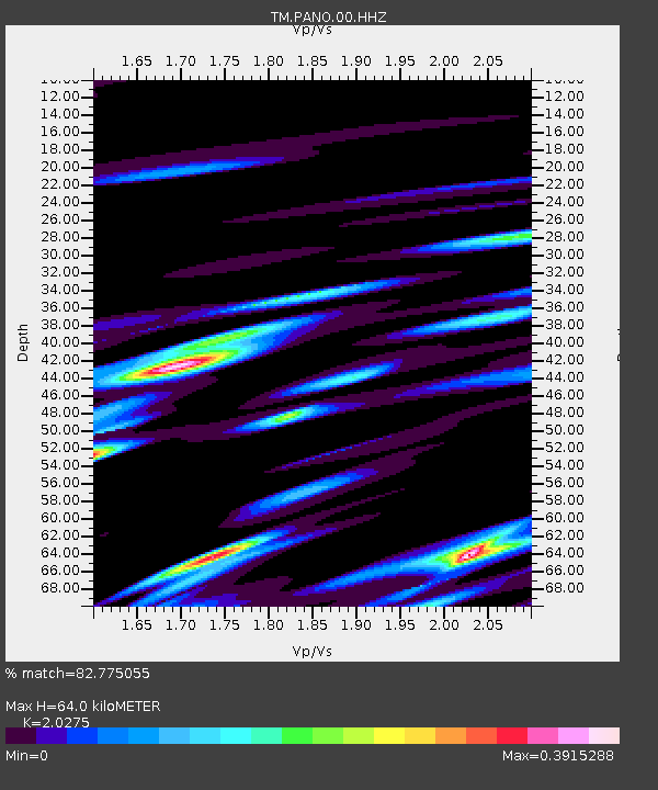
| Estimated Moho Depth: |
64.0 km |
| Estimated Crust Vp/Vs: |
2.03 |
| Assumed Crust Vp: |
6.498 km/s |
| Estimated Crust Vs: |
3.205 km/s |
| Estimated Crust Poisson's Ratio: |
0.34 |
|
| Radial Match: |
82.775055 % |
| Radial Bump: |
400 |
| Transverse Match: |
81.63268 % |
| Transverse Bump: |
400 |
| SOD ConfigId: |
30536071 |
| Insert Time: |
2023-03-22 06:33:57.385 +0000 |
| GWidth: |
2.5 |
| Max Bumps: |
400 |
| Tol: |
0.001 |
|

Signal To Noise
| Channel | StoN | STA | LTA |
| TM:PANO:00:HHZ:20230308T06:12:21.760012Z | 14.6926775 | 2.5426667E-7 | 1.7305673E-8 |
| TM:PANO:00:HHN:20230308T06:12:21.760012Z | 4.1742954 | 7.35142E-8 | 1.7611166E-8 |
| TM:PANO:00:HHE:20230308T06:12:21.760012Z | 1.066516 | 1.8263021E-8 | 1.7124002E-8 |
| Arrivals |
| Ps | 11 SECOND |
| PpPs | 28 SECOND |
| PsPs/PpSs | 39 SECOND |


