You are here: Home > Network List > US - United States National Seismic Network Stations List
> Station LAO LASA Array, Montana, USA > Earthquake Result Viewer
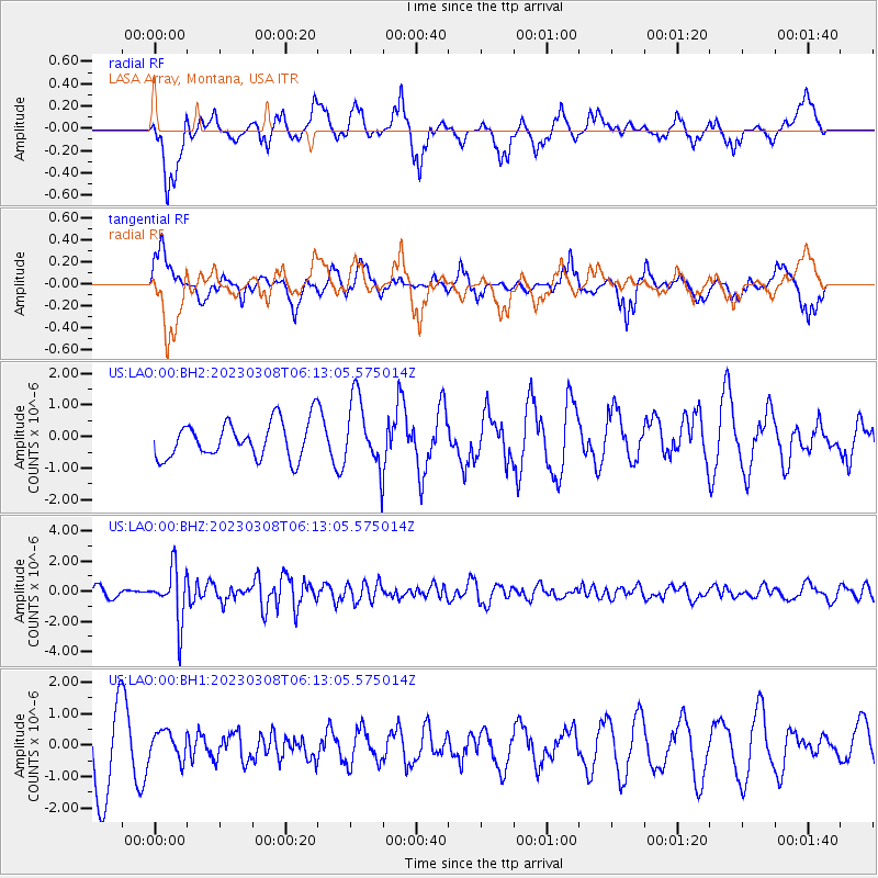
LAO LASA Array, Montana, USA - Earthquake Result Viewer
*The percent match for this event was below the threshold and hence no stack was calculated.
| Earthquake location: |
Kuril Islands |
| Earthquake latitude/longitude: |
50.1/157.4 |
| Earthquake time(UTC): |
2023/03/08 (067) 06:03:36 GMT |
| Earthquake Depth: |
36 km |
| Earthquake Magnitude: |
5.6 Mww |
| Earthquake Catalog/Contributor: |
NEIC PDE/us |
|
| Network: |
US United States National Seismic Network |
| Station: |
LAO LASA Array, Montana, USA |
| Lat/Lon: |
46.69 N/106.22 W |
| Elevation: |
902 m |
|
| Distance: |
59.6 deg |
| Az: |
52.503 deg |
| Baz: |
312.123 deg |
| Ray Param: |
$rayparam |
*The percent match for this event was below the threshold and hence was not used in the summary stack. |
|
| Radial Match: |
61.41184 % |
| Radial Bump: |
400 |
| Transverse Match: |
38.724995 % |
| Transverse Bump: |
344 |
| SOD ConfigId: |
30536071 |
| Insert Time: |
2023-03-22 06:37:05.530 +0000 |
| GWidth: |
2.5 |
| Max Bumps: |
400 |
| Tol: |
0.001 |
|
Signal To Noise
| Channel | StoN | STA | LTA |
| US:LAO:00:BHZ:20230308T06:13:05.575014Z | 5.8636246 | 1.7141024E-6 | 2.9232814E-7 |
| US:LAO:00:BH1:20230308T06:13:05.575014Z | 0.37655735 | 4.4690938E-7 | 1.1868295E-6 |
| US:LAO:00:BH2:20230308T06:13:05.575014Z | 1.9146689 | 1.1047648E-6 | 5.7700043E-7 |
| Arrivals |
| Ps | |
| PpPs | |
| PsPs/PpSs | |


