You are here: Home > Network List > GT - Global Telemetered Seismograph Network (USAF/USGS) Stations List
> Station PLCA Paso Flores, Argentina > Earthquake Result Viewer
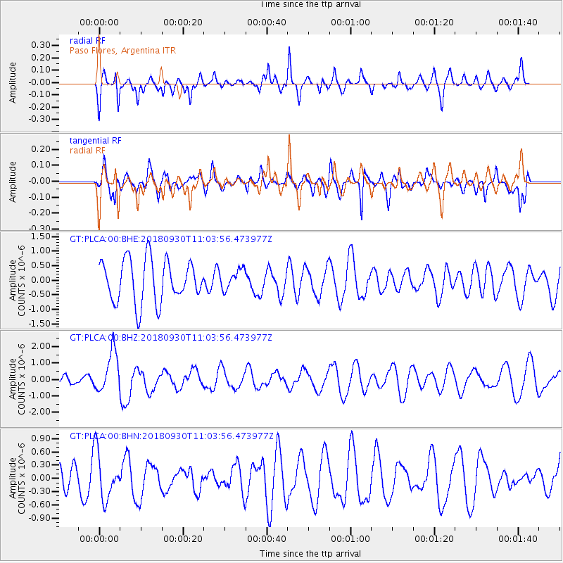
PLCA Paso Flores, Argentina - Earthquake Result Viewer
*The percent match for this event was below the threshold and hence no stack was calculated.
| Earthquake location: |
Fiji Islands Region |
| Earthquake latitude/longitude: |
-18.4/-178.1 |
| Earthquake time(UTC): |
2018/09/30 (273) 10:52:23 GMT |
| Earthquake Depth: |
551 km |
| Earthquake Magnitude: |
6.6 mww |
| Earthquake Catalog/Contributor: |
NEIC PDE/us |
|
| Network: |
GT Global Telemetered Seismograph Network (USAF/USGS) |
| Station: |
PLCA Paso Flores, Argentina |
| Lat/Lon: |
40.73 S/70.55 W |
| Elevation: |
1050 m |
|
| Distance: |
90.8 deg |
| Az: |
133.561 deg |
| Baz: |
244.901 deg |
| Ray Param: |
$rayparam |
*The percent match for this event was below the threshold and hence was not used in the summary stack. |
|
| Radial Match: |
57.765633 % |
| Radial Bump: |
400 |
| Transverse Match: |
58.84927 % |
| Transverse Bump: |
400 |
| SOD ConfigId: |
3045211 |
| Insert Time: |
2018-10-14 11:09:06.003 +0000 |
| GWidth: |
2.5 |
| Max Bumps: |
400 |
| Tol: |
0.001 |
|
Signal To Noise
| Channel | StoN | STA | LTA |
| GT:PLCA:00:BHZ:20180930T11:03:56.473977Z | 1.7308944 | 1.2773016E-6 | 7.379431E-7 |
| GT:PLCA:00:BHN:20180930T11:03:56.473977Z | 1.1534617 | 5.101659E-7 | 4.422911E-7 |
| GT:PLCA:00:BHE:20180930T11:03:56.473977Z | 0.4675674 | 3.423252E-7 | 7.3214085E-7 |
| Arrivals |
| Ps | |
| PpPs | |
| PsPs/PpSs | |


