You are here: Home > Network List > IC - New China Digital Seismograph Network Stations List
> Station ENH Enshi, Hubei Province, China > Earthquake Result Viewer
ENH Enshi, Hubei Province, China - Earthquake Result Viewer
*The percent match for this event was below the threshold and hence no stack was calculated.
| Earthquake location: |
Northern Molucca Sea |
| Earthquake latitude/longitude: |
1.0/126.2 |
| Earthquake time(UTC): |
2010/02/10 (041) 20:46:44 GMT |
| Earthquake Depth: |
42 km |
| Earthquake Magnitude: |
5.5 MB |
| Earthquake Catalog/Contributor: |
WHDF/NEIC |
|
| Network: |
IC New China Digital Seismograph Network |
| Station: |
ENH Enshi, Hubei Province, China |
| Lat/Lon: |
30.27 N/109.49 E |
| Elevation: |
487 m |
|
| Distance: |
33.1 deg |
| Az: |
332.864 deg |
| Baz: |
148.188 deg |
| Ray Param: |
$rayparam |
*The percent match for this event was below the threshold and hence was not used in the summary stack. |
|
| Radial Match: |
47.536907 % |
| Radial Bump: |
400 |
| Transverse Match: |
62.834053 % |
| Transverse Bump: |
400 |
| SOD ConfigId: |
305946 |
| Insert Time: |
2010-05-04 06:41:28.829 +0000 |
| GWidth: |
2.5 |
| Max Bumps: |
400 |
| Tol: |
0.001 |
|
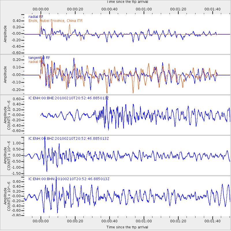
Signal To Noise
| Channel | StoN | STA | LTA |
| IC:ENH:00:BHZ:20100210T20:52:46.885013Z | 5.2800994 | 5.6930753E-7 | 1.07821364E-7 |
| IC:ENH:00:BHN:20100210T20:52:46.885013Z | 2.7960675 | 2.8832537E-7 | 1.03118175E-7 |
| IC:ENH:00:BHE:20100210T20:52:46.885013Z | 1.1547854 | 1.0274221E-7 | 8.897083E-8 |
| Arrivals |
| Ps | |
| PpPs | |
| PsPs/PpSs | |


