You are here: Home > Network List > IU - Global Seismograph Network (GSN - IRIS/USGS) Stations List
> Station XMAS Kiritimati Island, Republic of Kiribati > Earthquake Result Viewer
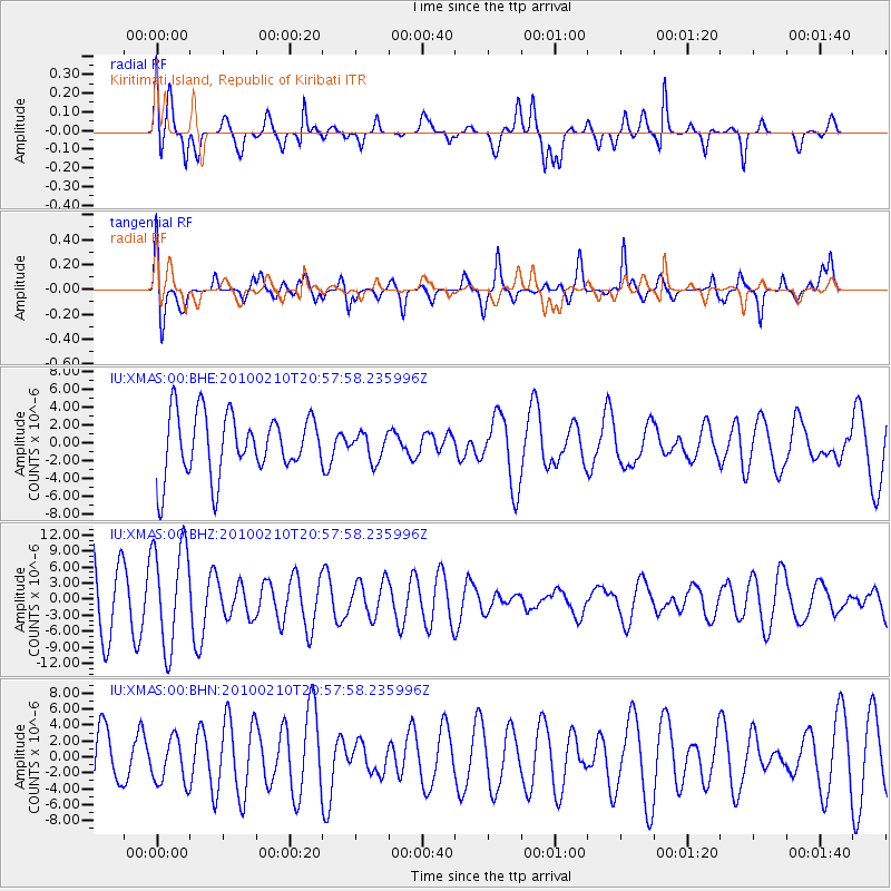
XMAS Kiritimati Island, Republic of Kiribati - Earthquake Result Viewer
*The percent match for this event was below the threshold and hence no stack was calculated.
| Earthquake location: |
Northern Molucca Sea |
| Earthquake latitude/longitude: |
1.0/126.2 |
| Earthquake time(UTC): |
2010/02/10 (041) 20:46:44 GMT |
| Earthquake Depth: |
42 km |
| Earthquake Magnitude: |
5.5 MB |
| Earthquake Catalog/Contributor: |
WHDF/NEIC |
|
| Network: |
IU Global Seismograph Network (GSN - IRIS/USGS) |
| Station: |
XMAS Kiritimati Island, Republic of Kiribati |
| Lat/Lon: |
2.04 N/157.45 W |
| Elevation: |
20 m |
|
| Distance: |
76.3 deg |
| Az: |
88.16 deg |
| Baz: |
270.565 deg |
| Ray Param: |
$rayparam |
*The percent match for this event was below the threshold and hence was not used in the summary stack. |
|
| Radial Match: |
46.9437 % |
| Radial Bump: |
400 |
| Transverse Match: |
60.731983 % |
| Transverse Bump: |
400 |
| SOD ConfigId: |
305946 |
| Insert Time: |
2010-05-04 06:42:11.207 +0000 |
| GWidth: |
2.5 |
| Max Bumps: |
400 |
| Tol: |
0.001 |
|
Signal To Noise
| Channel | StoN | STA | LTA |
| IU:XMAS:00:BHZ:20100210T20:57:58.235996Z | 1.7502252 | 9.550078E-6 | 5.4564853E-6 |
| IU:XMAS:00:BHN:20100210T20:57:58.235996Z | 0.7980917 | 2.8373104E-6 | 3.5551182E-6 |
| IU:XMAS:00:BHE:20100210T20:57:58.235996Z | 0.44655678 | 1.5151506E-6 | 3.3929632E-6 |
| Arrivals |
| Ps | |
| PpPs | |
| PsPs/PpSs | |


