You are here: Home > Network List > IU - Global Seismograph Network (GSN - IRIS/USGS) Stations List
> Station PMG Port Moresby, New Guinea > Earthquake Result Viewer
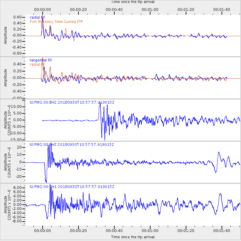
PMG Port Moresby, New Guinea - Earthquake Result Viewer
*The percent match for this event was below the threshold and hence no stack was calculated.
| Earthquake location: |
Fiji Islands Region |
| Earthquake latitude/longitude: |
-18.4/-178.1 |
| Earthquake time(UTC): |
2018/09/30 (273) 10:52:23 GMT |
| Earthquake Depth: |
551 km |
| Earthquake Magnitude: |
6.6 mww |
| Earthquake Catalog/Contributor: |
NEIC PDE/us |
|
| Network: |
IU Global Seismograph Network (GSN - IRIS/USGS) |
| Station: |
PMG Port Moresby, New Guinea |
| Lat/Lon: |
9.40 S/147.16 E |
| Elevation: |
90 m |
|
| Distance: |
34.8 deg |
| Az: |
280.067 deg |
| Baz: |
108.629 deg |
| Ray Param: |
$rayparam |
*The percent match for this event was below the threshold and hence was not used in the summary stack. |
|
| Radial Match: |
87.241776 % |
| Radial Bump: |
400 |
| Transverse Match: |
75.4489 % |
| Transverse Bump: |
400 |
| SOD ConfigId: |
3045211 |
| Insert Time: |
2018-10-14 11:09:43.680 +0000 |
| GWidth: |
2.5 |
| Max Bumps: |
400 |
| Tol: |
0.001 |
|
Signal To Noise
| Channel | StoN | STA | LTA |
| IU:PMG:00:BHZ:20180930T10:57:57.919015Z | 71.82027 | 1.3762767E-5 | 1.916279E-7 |
| IU:PMG:00:BH1:20180930T10:57:57.919015Z | 16.962189 | 3.6322197E-6 | 2.1413625E-7 |
| IU:PMG:00:BH2:20180930T10:57:57.919015Z | 32.4639 | 6.541385E-6 | 2.0149719E-7 |
| Arrivals |
| Ps | |
| PpPs | |
| PsPs/PpSs | |


